A tropical cyclone designated TWENTYNINE-26 is active in the Northwest Pacific and is affecting Guam, according to the Global Disaster Alert and Coordination System (GDACS), which has issued an Orange alert for the event. An Orange alert means conditions could cause significant local impacts and that monitoring and preparedness actions are warranted.
The system was active on October 14, 2026, and is classified as a Tropical Depression, though reported data indicate maximum wind speeds of up to 231 km/h (about 144 mph) — a figure consistent with a much stronger cyclone, so readers should treat official local forecasts as the most reliable source on current intensity. GDACS estimates that roughly 177,000 people in Guam could experience winds of at least 120 km/h (about 75 mph, equivalent to Category 1 hurricane strength) or higher. Guam’s overall vulnerability to this event is rated Medium.
What residents may notice
People in Guam should expect strong winds, heavy rainfall, rough seas, and the possibility of flash flooding in low-lying areas. Power outages and disruptions to water service, flights at Guam’s airport, and road travel are all possible while the system is in the area.
Sensible steps to take
First, follow guidance from local emergency management and the National Weather Service office in Guam, and secure loose outdoor items that could become wind-borne debris. Second, stock a basic kit with drinking water, non-perishable food, flashlights, batteries, and any needed medications for at least three days. Third, avoid coastal areas and flooded roads during the storm — most tropical cyclone injuries come from water, not wind.
This alert is based on data from GDACS, the EU Joint Research Centre’s Global Disaster Alert and Coordination System, with tropical cyclone tracking supported by NOAA and JTWC observations.
Frequently Asked Questions
Is Guam facing hurricane-force winds right now?
GDACS estimates about 177,000 people in Guam could see winds of 120 km/h (75 mph) or higher, which is Category 1 hurricane strength. Check the National Weather Service Guam forecast for the latest local intensity.
Should I evacuate or shelter in place?
Most residents in sound buildings shelter in place, away from windows. Follow any evacuation orders from Guam Homeland Security, especially if you live in a low-lying or coastal flood-prone area.
Will flights in and out of Guam be affected?
Cyclones of this strength typically cause flight delays and cancellations at Guam's airport while the storm is nearby. Check with your airline before heading to the airport.
How long will the storm last?
The system was active on October 14, 2026, and tropical cyclones typically affect an island for one to two days as they pass. Monitor local forecasts, as slow-moving storms can extend heavy rain and flooding risks.
Keep tracking this:
Source: GDACS (EU Joint Research Centre)
Related Reading





Map centered on the epicenter (9.60, 161.20). Map data © OpenStreetMap contributors.
Sky & Solar Conditions at the Time
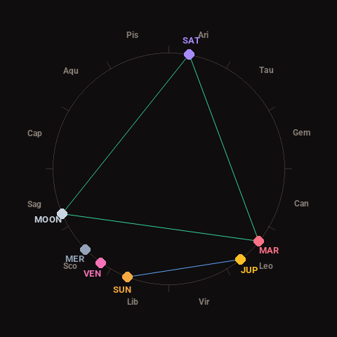
Moon: Waxing Crescent (15% illuminated), in Sagittarius.
Notable planetary angles: Sun sextile Jupiter (59°), Mars trine Saturn (119°), Moon trine Mars (118°), Moon trine Saturn (123°).
Concurrent space weather: planetary Kp index 2.3; strongest recent solar flare: nothing notable.
This is a factual snapshot, not a claim of cause and effect – researchers are divided on whether lunar, planetary or solar factors influence seismic or weather activity. It’s included so readers can track the pattern for themselves over time.