The National Weather Service office in Honolulu has issued a Tropical Storm Warning for the entire Big Island of Hawaii, effective as of 11:19 AM HST on September 24. The warning covers eight zones: Big Island Southeast, Big Island Interior, Kohala, Big Island South, Kona, Big Island East, Big Island Summit, and Big Island North.
A Tropical Storm Warning means that tropical storm conditions – sustained winds of 39 to 73 mph – are expected within the warning area, generally within 36 hours. Because the entire island is covered, residents and visitors everywhere from Kona to Hilo and up to the summit regions should take this seriously.
What You Might Notice
Expect strengthening winds, periods of heavy rain, and rough surf along exposed coastlines. Higher elevations, including the Big Island Summit zone, can see even stronger gusts. Power outages are possible as winds bring down tree branches and power lines, and flash flooding can develop quickly in areas of steep terrain and along streams. Roads may become impassable during heavy downpours, and flights in and out of Kona and Hilo airports could face delays or cancellations.
Sensible steps to take now:
– Secure or bring indoors anything outside that could become a wind-driven hazard – patio furniture, trash cans, plants.
– Charge phones and devices, and have flashlights, water, and basic supplies ready in case of power outages.
– Avoid driving through flooded roads – even shallow moving water can sweep away a vehicle – and stay away from the shoreline as surf builds.
– Monitor local radio or county civil defense messages for updated advisories, especially if you are in a flood-prone area or near a gulch or stream.
Conditions will be updated as the storm’s track and intensity become clearer, so check for the latest bulletins through the day.
Data source: National Weather Service (NWS) Honolulu, HI.
Frequently Asked Questions
What does a Tropical Storm Warning actually mean?
It means tropical storm conditions – sustained winds of 39 to 73 mph, plus heavy rain – are expected in the warned area, typically within 36 hours. It is a step beyond a Tropical Storm Watch, which only means those conditions are possible.
What should I do right now?
Secure outdoor items, charge your devices, and make sure you have water, flashlights, and any needed medications on hand. Finish preparations before winds pick up, and stay off the roads once heavy rain begins.
Is the whole Big Island affected, or just one coast?
The warning covers all eight Big Island zones – Kona, Kohala, North, South, East, Southeast, Interior, and Summit – so no part of the island is outside the warned area. Wind and rain impacts may still vary by location, with higher terrain typically seeing stronger gusts.
Will flights and roads be affected?
Delays and cancellations are possible at Kona and Hilo airports as conditions worsen, and heavy rain can cause flash flooding that closes roads, especially near streams and gulches. Check with your airline and county road reports before traveling.
Keep tracking this:
Source: National Weather Service (NWS)
Related Reading
- Emergency Communication: Staying Connected When Towers Go Down
- Earthquake Survival: Precautions, Kit & Early Warning in 2026
- Essential Guide to Preparing for a Nuclear War
Sky & Solar Conditions at the Time
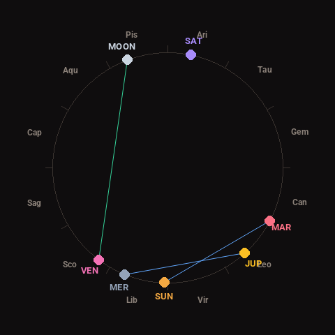
Moon: Full Moon (96% illuminated), in Pisces.
Notable planetary angles: Moon trine Venus (123°), Mercury sextile Jupiter (64°), Sun sextile Mars (64°).
Concurrent space weather: planetary Kp index 2.0; strongest recent solar flare: nothing notable.
This is a factual snapshot, not a claim of cause and effect – researchers are divided on whether lunar, planetary or solar factors influence seismic or weather activity. It’s included so readers can track the pattern for themselves over time.