The National Weather Service office in St. Louis, Missouri has issued a Flood Warning effective September 25 at 12:14 PM CDT, running through September 28 at 1:00 AM CDT. The warning covers 18 areas, including Pike and Calhoun counties in Illinois; Marion and Pike counties in Missouri; Louisa, Clinton, and Scott counties in Iowa; Dutchess and Ulster counties in New York; and Brewster County in Texas, plus eight additional areas.
A Flood Warning means flooding is already occurring or is imminent – this is a step above a Flood Watch, which only means conditions are favorable. Many of the affected counties sit along the Mississippi River corridor, where water levels are expected to run above flood stage, affecting low-lying roads, farmland, riverfront property, and boat landings. The New York and Texas listings are separate river or flash-flood concerns being tracked under the same warning feed.
What readers might notice
Residents in river-adjacent communities may see water covering low roads, rising levels in creeks and drainage ditches, and temporary road closures – particularly along smaller rural routes near the Mississippi. Farmers in the affected Iowa, Illinois, and Missouri counties should watch bottomland fields. In the Hudson Valley counties of New York, watch for swollen streams and poor-drainage street flooding.
Practical steps for anyone in the warned areas:
1. Never drive through standing water. Six inches of moving water can knock a person down, and twelve inches can carry away a small car. Turn around, don’t drown.
2. Move valuables and vehicles to higher ground if you live in a low-lying or riverside spot, and keep phones charged in case of evacuation notices.
3. Monitor river forecasts for your specific county, since crest timing varies along the river – some locations may peak well before the warning expires early Sunday morning.
This alert is based on data from the National Weather Service (NWS) St. Louis office, part of NOAA.
Frequently Asked Questions
Is this flooding dangerous right now, or just a precaution?
A Flood Warning means flooding is occurring or imminent in the listed areas, not just possible. If you live near the Mississippi River in the affected Illinois, Missouri, or Iowa counties, treat it as an active situation and avoid low-water crossings.
Why are New York and Texas counties included in a warning from the St. Louis office?
The warning feed bundles multiple areas tracked nationally, but each county has its own local flood concern. Dutchess and Ulster counties in New York and Brewster County in Texas are dealing with separate river or heavy-rain events monitored by their regional NWS offices.
How long will the flooding last?
This warning currently runs until 1:00 AM CDT on September 28, though river flooding can linger after warnings expire as water slowly recedes. Check for updated statements, since warnings are often extended or trimmed as crests pass.
What should I do right now if I'm in one of these counties?
Avoid driving on flooded roads, move items out of basements or low ground near waterways, and stay tuned to local alerts. If water is rising near your home, be ready to leave for higher ground without waiting for an official order.
Keep tracking this:
Source: National Weather Service (NWS)
Related Reading
- Emergency Communication: Staying Connected When Towers Go Down
- Earthquake Survival: Precautions, Kit & Early Warning in 2026
- Essential Guide to Preparing for a Nuclear War
Sky & Solar Conditions at the Time
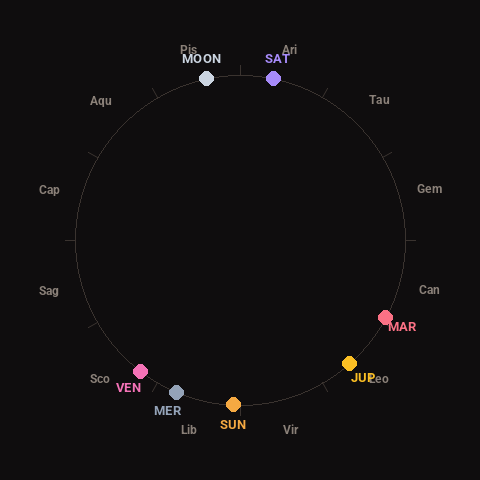
Moon: Full Moon (99% illuminated), in Pisces.
Notable planetary angles: none within a tight orb at this time.
Concurrent space weather: planetary Kp index 2.3; strongest recent solar flare: nothing notable.
This is a factual snapshot, not a claim of cause and effect – researchers are divided on whether lunar, planetary or solar factors influence seismic or weather activity. It’s included so readers can track the pattern for themselves over time.