The National Weather Service has issued a Flood Warning covering 13 counties in two regions: parts of the Hudson Valley in New York and several river counties along the Mississippi corridor in Iowa, Illinois, and Missouri. The alert was issued on September 25 at 10:21 PM EDT and remains in effect through September 26 at 8:15 PM EDT.
A Flood Warning means flooding is occurring or is imminent — this is a step beyond a Flood Watch, which only signals that conditions are favorable. Residents in the affected counties should treat this as an active, ongoing event rather than a possibility.
Who is affected
In New York, the warning covers Dutchess and Ulster counties along the Hudson River. In the Midwest, it covers Louisa, Clinton, and Scott counties in Iowa; Pike, Calhoun, and Lake counties in Illinois; and Pike and Marion counties in Missouri, among others. The Midwest portion of this warning is typical of river flooding along the Mississippi and its tributaries, where water levels can rise slowly and stay elevated for days.
What you might notice: water over roads, especially low-lying and rural routes; rivers and streams running high and fast; standing water in fields, basements, and underpasses; and possible road closures near river crossings. In urban areas like the Quad Cities (Davenport–Bettendorf area in Scott County), watch for street flooding during heavier rainfall periods.
Practical steps:
1. Never drive through flooded roads. Six inches of moving water can knock a person down, and a foot can float a vehicle. Turn around and find another route.
2. If you live near a river or creek in the warned counties, move valuables off basement floors and be ready to relocate to higher ground if water begins rising near your property.
3. Check on road conditions before commuting Thursday morning, particularly along river roads in the Quad Cities area and low-lying routes in Dutchess and Ulster counties.
Data for this alert comes from the National Weather Service (NWS Albany, NY office and regional offices covering the Midwest counties).
Frequently Asked Questions
What should I do right now if I'm in one of these counties?
Avoid driving on flooded roads, stay away from riverbanks and fast-moving water, and move anything valuable out of basements or ground floors if you live near a waterway. Keep your phone charged and monitor local NWS updates through Thursday evening.
How long will this flooding last?
The current warning runs through 8:15 PM EDT on September 26, but river flooding in the Mississippi corridor counties can persist for several days after a warning expires. Follow-up warnings or extensions are common if water levels stay high.
Is the flooding in New York connected to the flooding in Iowa and Illinois?
No — these are separate events bundled under one alert feed. The Hudson Valley counties are dealing with a local weather system, while the Midwest counties are experiencing river flooding along the Mississippi and its tributaries.
Is it safe to drive to work in the Quad Cities area Thursday morning?
Main highways are generally manageable, but low-lying river roads and streets near the Mississippi in Scott and Rock Island-area counties may have closures or standing water. Check local road reports before leaving and never cross a barricaded or water-covered road.
Keep tracking this:
Source: National Weather Service (NWS)
Related Reading
- Emergency Communication: Staying Connected When Towers Go Down
- Earthquake Survival: Precautions, Kit & Early Warning in 2026
- Essential Guide to Preparing for a Nuclear War
Sky & Solar Conditions at the Time
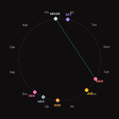
Moon: Full Moon (100% illuminated), in Pisces.
Notable planetary angles: Moon trine Mars (124°).
Concurrent space weather: planetary Kp index 2.7; strongest recent solar flare: nothing notable.
This is a factual snapshot, not a claim of cause and effect – researchers are divided on whether lunar, planetary or solar factors influence seismic or weather activity. It’s included so readers can track the pattern for themselves over time.