The National Weather Service office in Tiyan, Guam, has issued a Tropical Storm Warning for Saipan and Tinian, along with the surrounding coastal waters of both islands. The warning was issued at 3:23 PM Chamorro Standard Time (ChST) on October 3.
A Tropical Storm Warning means that tropical storm conditions — sustained winds of 39 to 73 miles per hour, often accompanied by heavy rain — are expected within the warning area, typically within 36 hours. Unlike a tropical storm watch, which signals possible conditions, a warning means hazardous weather is expected, and protective actions should be completed promptly.
The warning currently covers four areas: the islands of Saipan and Tinian themselves, plus the Tinian Coastal Waters and Saipan Coastal Waters zones, which include the nearshore ocean areas used by small boats and inter-island vessels.
What residents may notice
People on Saipan and Tinian should expect strengthening winds, periods of heavy rainfall, rough surf, and potentially hazardous sea conditions. Power outages are possible if winds bring down tree limbs or power lines. Loose outdoor items such as patio furniture, tarps, and trash bins can become airborne in tropical storm winds and should be secured or brought inside. Mariners should remain in port, as coastal waters will become dangerous for small craft.
Practical steps now
Residents should take a few sensible precautions before conditions deteriorate. First, secure or store outdoor items and check that windows and shutters are ready. Second, top off supplies: drinking water, non-perishable food, flashlights with fresh batteries, charged phones and power banks, and any needed medications. Third, stay informed by monitoring local radio and official updates from the NWS Guam office and CNMI emergency management, and avoid beaches, reefs, and coastal roads as surf builds.
Tropical storms in the western North Pacific can intensify or shift track, so it is worth checking for updated advisories even after initial preparations are complete. If the system strengthens to typhoon intensity, the warning level will be upgraded accordingly.
Data and official wording for this alert come from the National Weather Service (NWS) office in Tiyan, Guam, part of NOAA.
Frequently Asked Questions
What should I do right now?
Secure loose outdoor items, stock up on water, food, batteries, and medications, and charge your devices. Finish preparations before winds strengthen, since a warning means tropical storm conditions are expected, not just possible.
How long will this last?
A warning is typically issued when conditions are expected within about 36 hours, and the worst weather usually passes within a day once the storm moves through. Monitor NWS Guam updates for timing specific to this system's track.
Is it safe to go out on the water or to the beach?
No. Saipan and Tinian Coastal Waters are included in the warning, meaning seas will be rough and dangerous for small craft, and surf along shorelines will be hazardous. Mariners should stay in port and everyone should avoid beaches and reefs.
Could this storm get stronger?
Yes. Tropical storms in the western Pacific can intensify into typhoons, and if that happens the warning would be upgraded. Keep checking official NWS and CNMI emergency management updates for any changes in strength or track.
Keep tracking this:
Source: National Weather Service (NWS)
Related Reading
- Emergency Communication: Staying Connected When Towers Go Down
- Earthquake Survival: Precautions, Kit & Early Warning in 2026
- Essential Guide to Preparing for a Nuclear War
Sky & Solar Conditions at the Time
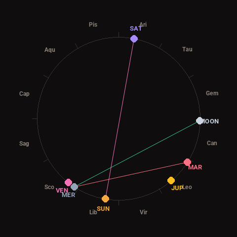
Moon: Last Quarter (57% illuminated), in Cancer.
Notable planetary angles: Mercury square Mars (90°), Moon trine Mercury (121°), Sun opposite Saturn (178°).
Concurrent space weather: planetary Kp index 2.3; strongest recent solar flare: nothing notable.
This is a factual snapshot, not a claim of cause and effect – researchers are divided on whether lunar, planetary or solar factors influence seismic or weather activity. It’s included so readers can track the pattern for themselves over time.