The National Weather Service in Des Moines has issued a Flood Warning covering 67 areas, effective from 4:06 AM CDT on October 3 through 8:30 PM CDT on October 4. Affected counties include Marion, Polk, Warren, Black Hawk, Jasper, Dallas, Marshall, and Story in Iowa, along with Bent County, Colorado and Greeley County, Kansas, plus dozens more areas.
A Flood Warning means flooding is already occurring or is expected shortly — it is more serious than a watch or advisory. Residents in the warned areas may see water covering roads, rising creeks and small rivers, flooded basements, and standing water in low-lying spots, underpasses, and fields. Rural roads in agricultural areas are especially prone to washouts and closures.
Polk County includes the Des Moines metro area, and Black Hawk County includes Waterloo and Cedar Falls, so a significant population lives within the warning footprint. Morning commuters on October 3 and 4 should expect possible road closures, detours, and slower travel, particularly on secondary roads that cross creeks or dip through low ground.
What to watch and how to prepare
1. Never drive through water-covered roads. Six inches of moving water can knock a person down, and a foot can float many vehicles. Turn around and find another route — most flood deaths happen in cars.
2. Move valuables off basement floors and check that sump pumps are working if you live in a flood-prone part of the warned counties.
3. Monitor local NWS updates through the evening of October 4. The warning currently runs until 8:30 PM CDT, but it could be extended if water rises slower or faster than expected. Charge phones in case of localized power interruptions.
This information comes from the National Weather Service (NWS) office in Des Moines, Iowa.
Frequently Asked Questions
What does a Flood Warning mean compared to a Flood Watch?
A Flood Warning means flooding is already happening or imminent in the warned areas. A watch only means conditions are favorable — a warning calls for immediate caution, especially around roads and waterways.
Is Des Moines affected?
Yes — Polk County, which includes Des Moines, is among the 67 areas listed, along with nearby counties like Warren, Dallas, and Jasper. Watch for flooded low spots and road closures in and around the metro.
How long will this flooding last?
The warning currently runs through 8:30 PM CDT on October 4, covering roughly two days. The NWS may extend or cancel it early depending on how quickly water levels rise and recede.
Is it safe to drive to work if the roads look wet?
Wet roads are generally fine, but never drive through standing or moving water of unknown depth — turn around instead. Check local road conditions before leaving, as rural and low-lying routes in the warned counties are the most likely to close.
Keep tracking this:
Source: National Weather Service (NWS)
Related Reading
- Emergency Communication: Staying Connected When Towers Go Down
- Earthquake Survival: Precautions, Kit & Early Warning in 2026
- Essential Guide to Preparing for a Nuclear War
Sky & Solar Conditions at the Time
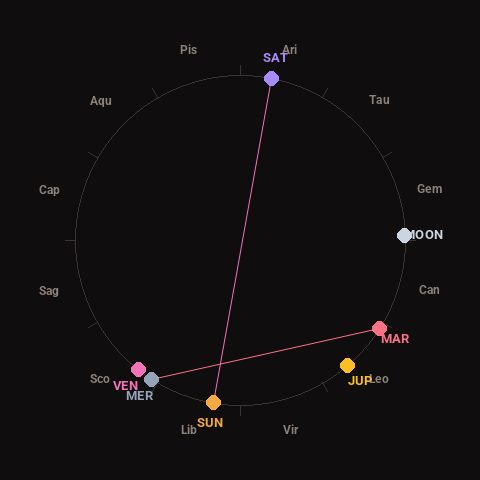
Moon: Last Quarter (59% illuminated), in Gemini.
Notable planetary angles: Mercury square Mars (90°), Sun opposite Saturn (178°).
Concurrent space weather: planetary Kp index 2.7; strongest recent solar flare: nothing notable.
This is a factual snapshot, not a claim of cause and effect – researchers are divided on whether lunar, planetary or solar factors influence seismic or weather activity. It’s included so readers can track the pattern for themselves over time.