The National Weather Service office in Tiyan, Guam, has issued a Tropical Storm Warning for the islands of Saipan and Tinian in the Commonwealth of the Northern Mariana Islands, including their surrounding coastal waters. The warning was issued at 4:40 AM ChST on October 18 (ChST is Chamorro Standard Time, 14 hours ahead of U.S. Eastern Time). Four areas are covered: Tinian, Saipan, Tinian Coastal Waters, and Saipan Coastal Waters.
A Tropical Storm Warning means that tropical-storm-force winds — sustained winds of 39 mph or greater — are expected within the warning area, typically within 36 hours. Residents on Saipan and Tinian should expect strengthening winds, heavy rain, and rough seas as the system approaches or passes near the islands.
What residents may notice
Winds will build through the day, with gusts strong enough to bring down tree branches, loose outdoor items, and possibly power lines. Heavy rainfall can cause localized flooding, especially in low-lying areas and along roads with poor drainage. Coastal waters around both islands will become dangerous, with high surf and strong currents making any small-craft travel hazardous. Power outages and interruptions to water or communications are possible on islands this size, where infrastructure can be vulnerable to storm damage.
Anyone living on or visiting Saipan and Tinian is affected, along with boaters and fishers operating in nearby waters. Flights to and from Saipan International Airport may face delays or cancellations as conditions worsen.
What to do now
Secure or bring inside anything outdoors that could become airborne — furniture, trash cans, tools, and decorations. Charge phones and power banks, fill containers with drinking water, and check flashlights and batteries in case of outages. Stay off the water entirely, and avoid coastal roads and shorelines once surf builds. If flooding is a concern in your area, move valuables and important documents to higher ground and know your nearest shelter location.
This alert is based on data from the National Weather Service (NWS) office in Tiyan, Guam, which issues official tropical cyclone warnings for the Mariana Islands.
Frequently Asked Questions
What should I do right now if I'm on Saipan or Tinian?
Secure loose outdoor items, charge devices, gather water and flashlights, and stay off the roads and water once winds pick up. Tropical-storm-force winds (39 mph or more) are expected within the warning window.
What does a Tropical Storm Warning actually mean?
It means sustained winds of 39 mph or greater are expected in the warned area, generally within 36 hours. It is one step below a typhoon warning but still warrants securing property and staying indoors.
Is it safe to travel by boat or fly during this warning?
No — the warning covers Tinian and Saipan Coastal Waters, meaning seas will be dangerous for all marine activity. Flights may also be delayed or canceled, so check with your airline before heading to the airport.
How will I know if the situation gets worse?
Monitor updates from NWS Tiyan and local CNMI emergency management. If the system strengthens, the warning could be upgraded to a typhoon warning, which would signal sustained winds of 74 mph or more.
Keep tracking this:
Source: National Weather Service (NWS)
Related Reading
- Emergency Communication: Staying Connected When Towers Go Down
- Earthquake Survival: Precautions, Kit & Early Warning in 2026
- Essential Guide to Preparing for a Nuclear War
Sky & Solar Conditions at the Time
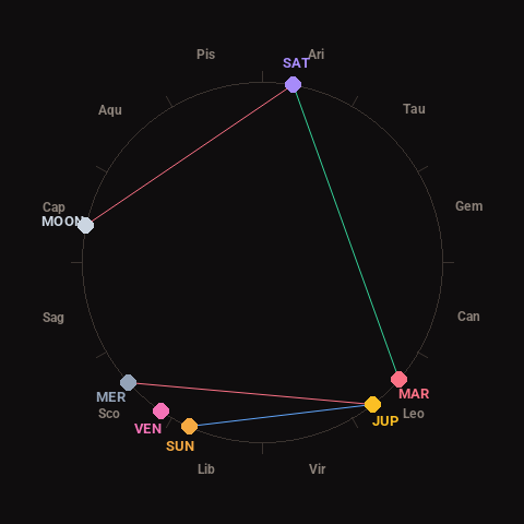
Moon: First Quarter (40% illuminated), in Capricorn.
Notable planetary angles: Mars trine Saturn (121°), Moon square Saturn (88°), Sun sextile Jupiter (62°), Mercury square Jupiter (86°).
Concurrent space weather: planetary Kp index 2.7; strongest recent solar flare: nothing notable.
This is a factual snapshot, not a claim of cause and effect – researchers are divided on whether lunar, planetary or solar factors influence seismic or weather activity. It’s included so readers can track the pattern for themselves over time.