The National Weather Service office in Salt Lake City has issued a Flash Flood Warning for Kane and Washington counties in southwestern Utah. The warning was issued at 8:15 AM MDT on October 21 and remains in effect until 11:15 AM MDT the same morning.
A Flash Flood Warning means flooding is already occurring or is imminent in the warned area — this is an upgrade from a watch and calls for immediate attention, not just awareness. Residents in and around the warned counties may notice rapidly rising water in normally dry washes, slot canyons, and small streams, as well as water flowing across low-lying roads. This region of Utah, which includes popular terrain near Zion National Park and the St. George area, is particularly prone to flash flooding because heavy rain on hard desert soil runs off quickly into canyons and drainages.
Everyone in Kane and Washington counties should take this seriously through at least late morning. That includes local residents, commuters, and visitors recreating outdoors.
What to do right now
If you are in a warned area, move away from washes, arroyos, and canyon bottoms — even if it is not raining directly overhead, runoff from storms miles away can arrive suddenly. Never drive or walk through water covering a road; six inches of moving water can knock a person down, and two feet can carry away a vehicle. If you are hiking in slot canyons or backcountry areas, get to higher ground immediately.
Keep an eye on local conditions until the warning expires at 11:15 AM MDT, and be ready for possible extensions or new warnings if storms continue. Charge your phone and monitor official alerts in case conditions worsen.
This alert is based on data from the National Weather Service (NWS) Salt Lake City office.
Frequently Asked Questions
What should I do right now if I'm in Kane or Washington County?
Move away from washes, stream beds, and canyon bottoms, and never attempt to cross flooded roads on foot or in a vehicle. Stay on higher ground and monitor official NWS alerts until the warning expires at 11:15 AM MDT.
How long will this warning last?
The current warning runs until 11:15 AM MDT on October 21, but the National Weather Service may extend it or issue new warnings if heavy rain continues over the area.
Is it dangerous even if it isn't raining where I am?
Yes. Flash floods in southern Utah are often caused by rain falling miles upstream, and a wall of water can arrive in a canyon or wash with little warning under clear local skies.
I'm visiting Zion or the St. George area — should I change my plans?
Avoid slot canyons and backcountry routes entirely while the warning is active, and check with park rangers or local officials before heading out. Paved main roads are generally safer, but never drive through standing or moving water.
Keep tracking this:
Source: National Weather Service (NWS)
Related Reading
- Emergency Communication: Staying Connected When Towers Go Down
- Earthquake Survival: Precautions, Kit & Early Warning in 2026
- Essential Guide to Preparing for a Nuclear War
Sky & Solar Conditions at the Time
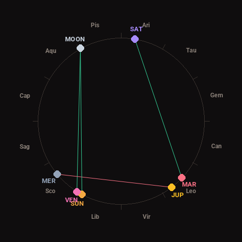
Moon: Waxing Gibbous (77% illuminated), in Pisces.
Notable planetary angles: Moon trine Venus (119°), Mercury square Jupiter (88°), Sun trine Moon (123°), Mars trine Saturn (123°).
Concurrent space weather: planetary Kp index 2.3; strongest recent solar flare: nothing notable.
This is a factual snapshot, not a claim of cause and effect – researchers are divided on whether lunar, planetary or solar factors influence seismic or weather activity. It’s included so readers can track the pattern for themselves over time.