The National Weather Service office in Fairbanks has issued a Blizzard Warning for a large stretch of western Alaska, in effect from early Thursday, October 23 at 2:56 AM AKDT until 1:00 AM AKDT on Friday, October 24.
The warning covers ten zones: Shishmaref, the Bering Strait Coast, the Interior Seward Peninsula, Eastern Norton Sound and the Nulato Hills, Kivalina and Red Dog Dock, the Lower Kobuk Valley, the Baldwin Peninsula, the Northern Seward Peninsula, the Southern Seward Peninsula Coast, and the Western Arctic Coast.
A Blizzard Warning means snow or blowing snow combined with winds of at least 35 mph is expected to drop visibility to a quarter mile or less for three hours or more. In plain terms: whiteout conditions, drifting snow, and travel that can quickly become dangerous or impossible.
Residents in these communities can expect near-zero visibility at times, rapidly drifting snow that can block doors and roads, wind chill values well below the actual air temperature, and disruptions to local air service, which is a primary transportation link for many of these villages. Power interruptions are also possible where wind stresses lines and equipment.
What to do now
Avoid travel. If you must move between buildings or check on neighbors, let someone know your route and expected return time. Whiteout conditions can disorient people within steps of their own door.
Prepare for outages. Charge phones and devices, keep flashlights and extra batteries handy, and have warm layers and blankets accessible in case heating systems lose power.
Check on elders and neighbors, secure loose items outdoors before winds peak, and make sure heating fuel and essential supplies are within reach. Keep generators outdoors and away from windows to prevent carbon monoxide poisoning.
Conditions should begin improving after the warning expires early Friday morning, though lingering blowing snow and drifted routes may slow cleanup. Monitor updates from local radio, community alerts, and the National Weather Service, which is the source of this warning data.
Frequently Asked Questions
What does a Blizzard Warning actually mean?
It means winds of 35 mph or more combined with falling or blowing snow will reduce visibility to a quarter mile or less for at least three hours. It is a call to stay off the roads and indoors, not just a heavy snow forecast.
How long will this blizzard last?
The warning runs from early Thursday, October 23 until 1:00 AM AKDT on Friday, October 24, so the worst conditions should ease by early Friday. Drifting and cleanup may take longer in exposed coastal areas.
Is it safe to travel between villages or fly?
No – whiteout conditions make overland travel extremely dangerous, and small-aircraft service that connects these communities is typically grounded during blizzard conditions. Postpone non-essential travel until the warning expires.
Should I worry about losing power or heat?
Outages are possible with strong winds, so charge devices now and have blankets, flashlights, and warm layers ready. If you use a generator, keep it outdoors and away from windows to avoid carbon monoxide buildup.
Keep tracking this:
Source: National Weather Service (NWS)
Related Reading
- Emergency Communication: Staying Connected When Towers Go Down
- Earthquake Survival: Precautions, Kit & Early Warning in 2026
- Essential Guide to Preparing for a Nuclear War
Sky & Solar Conditions at the Time
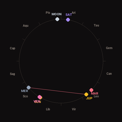
Moon: Waxing Gibbous (91% illuminated), in Pisces.
Notable planetary angles: Sun conjunct Venus (1°), Mercury square Jupiter (88°).
Concurrent space weather: planetary Kp index 1.7; strongest recent solar flare: nothing notable.
This is a factual snapshot, not a claim of cause and effect – researchers are divided on whether lunar, planetary or solar factors influence seismic or weather activity. It’s included so readers can track the pattern for themselves over time.