The National Weather Service office in Boston/Norton, Massachusetts, issued a Flood Warning on September 27 at 9:44 PM EDT that remains in effect until September 29 at 4:00 PM EDT. The warning covers nine areas spread across six states: Bristol and Plymouth counties in Massachusetts; Marshall County in Kansas; Clinton and Scott counties in Iowa; Lake County in Illinois; Lake and Volusia counties in Florida; and Somerset County in New Jersey.
A Flood Warning means flooding is already occurring or is imminent in the warned areas – this is a step beyond a Flood Watch, which only means conditions are favorable. Residents in these counties may notice water over roadways, especially in low-lying spots and near streams, rivers, and poor-drainage urban areas. Basements and ground floors in flood-prone neighborhoods could see water intrusion, and some local roads may be closed without much notice.
What to keep in mind
First, never drive or walk through floodwater. Six inches of moving water can knock an adult down, and a foot of water can float most vehicles – the depth of water on a flooded road is nearly impossible to judge at night. If you encounter a barricaded or flooded road, turn around.
Second, if you live in a basement apartment or low-lying area in any of the warned counties, move valuables, documents, and electronics to higher ground now, and know your quickest route to higher elevation. Keep your phone charged and enable wireless emergency alerts.
Third, conditions can change overnight while you sleep. Check local forecasts again in the morning, and follow instructions from county emergency management if evacuations or road closures are announced. The warning currently runs through 4:00 PM EDT on September 29, but it could be extended, expanded, or allowed to expire early depending on how water levels respond.
This alert is based on data issued by the National Weather Service (NWS) Boston/Norton office.
Frequently Asked Questions
Why does one warning cover counties in six different states?
The warning feed lists nine separate areas – in Massachusetts, Kansas, Iowa, Illinois, Florida, and New Jersey – under this issuance, each of which is experiencing or expecting flooding from its own local conditions, such as heavy rain or rising rivers.
What should I do right now if I'm in one of the warned counties?
Avoid driving through any standing or moving water, move items off basement floors, and keep a phone charged with emergency alerts enabled. If water is rising near your home, move to higher ground without waiting for an official order.
How long will this last?
The warning is currently set to expire at 4:00 PM EDT on September 29, but NWS may extend it if flooding persists or cancel it early if waters recede sooner than expected.
Is it safe to drive if the water on the road looks shallow?
No – depth and current are easy to misjudge, and the road underneath may be washed out. Just 12 inches of moving water can carry away a small car, so turn around and find another route.
Keep tracking this:
Source: National Weather Service (NWS)
Related Reading
- Emergency Communication: Staying Connected When Towers Go Down
- Earthquake Survival: Precautions, Kit & Early Warning in 2026
- Essential Guide to Preparing for a Nuclear War
Sky & Solar Conditions at the Time
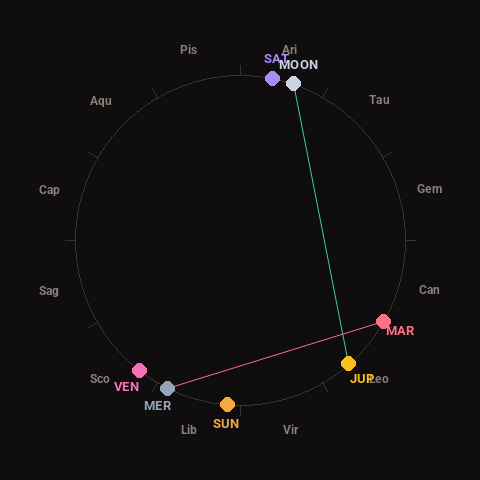
Moon: Full Moon (98% illuminated), in Aries.
Notable planetary angles: Moon trine Jupiter (120°), Mercury square Mars (87°).
Concurrent space weather: planetary Kp index 4.0; strongest recent solar flare: nothing notable.
This is a factual snapshot, not a claim of cause and effect – researchers are divided on whether lunar, planetary or solar factors influence seismic or weather activity. It’s included so readers can track the pattern for themselves over time.