The National Weather Service office in Tallahassee, Florida issued a Hurricane Warning at 11:07 AM EDT on October 9, covering 46 areas across the Florida Panhandle and adjacent coastal waters. A Hurricane Warning means hurricane conditions — sustained winds of 74 mph or higher — are expected within the warned area, typically within 36 hours. Preparations to protect life and property should be rushed to completion.
The warning covers a stretch of the central and eastern Panhandle, including coastal and inland communities in Bay, Walton, Coffee, and surrounding counties. Affected zones include St. Andrews Bay Waterways, Coastal Bay, Inland Bay, North and South Walton, and Central Walton, along with nearshore and offshore waters from the Okaloosa-Walton county line to Mexico Beach and Apalachicola, out to 60 nautical miles. In total, 46 distinct zones are included.
What readers in the area might notice
Residents should expect conditions to deteriorate through the day: strengthening winds, heavy rain bands, rising surf, and possible power outages as the storm approaches. Coastal zones face the added threat of storm surge — abnormal rises in water pushed ashore by the hurricane — which is often the most dangerous part of these storms. Marine interests in the warned waters should already be in port; small craft should not attempt to remain at sea.
Sensible steps right now
1. Finish preparations quickly. Secure outdoor items, charge phones and power banks, fill vehicles with fuel, and gather medications, water, and documents into a go-bag. 2. Know your evacuation zone. If local officials order an evacuation for your area, leave early and follow designated routes — do not wait for conditions to worsen. 3. Stay indoors once winds arrive. The calm eye of a storm is not the end — conditions can return violently from the opposite direction.
This alert is based on official warning data from the National Weather Service (NWS Tallahassee) and NOAA.
Frequently Asked Questions
What does a Hurricane Warning actually mean?
It means hurricane-force winds (74 mph or greater) are expected in the warned area, generally within 36 hours — not just possible. All storm preparations should be completed as soon as possible.
Which areas are covered by this warning?
The warning covers 46 zones across the Florida Panhandle, including Bay, Walton, and Coffee counties, plus coastal and offshore waters from the Okaloosa-Walton line to Mexico Beach and Apalachicola out to 60 nautical miles.
Should I evacuate?
Follow instructions from your local emergency management officials, who issue evacuation orders by zone. If you are in a coastal or low-lying area near St. Andrews Bay or the Walton/Bay coast and are told to leave, do so promptly.
Is the danger just from wind?
No — storm surge and inland flooding from heavy rain are often more deadly than wind in Panhandle hurricanes. Avoid driving through flooded roads, and stay away from the coast until officials give the all-clear.
Keep tracking this:
Source: National Weather Service (NWS)
Related Reading
- Emergency Communication: Staying Connected When Towers Go Down
- Earthquake Survival: Precautions, Kit & Early Warning in 2026
- Essential Guide to Preparing for a Nuclear War
Sky & Solar Conditions at the Time
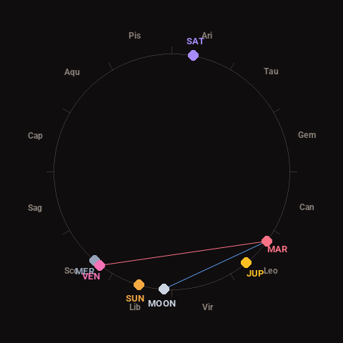
Moon: New Moon (1% illuminated), in Libra.
Notable planetary angles: Venus square Mars (91°), Moon sextile Mars (57°), Mercury conjunct Venus (4°).
Concurrent space weather: planetary Kp index 2.0; strongest recent solar flare: M1.4-class.
This is a factual snapshot, not a claim of cause and effect – researchers are divided on whether lunar, planetary or solar factors influence seismic or weather activity. It’s included so readers can track the pattern for themselves over time.