The National Weather Service office in Birmingham, Alabama, issued a Tropical Storm Warning at 10:17 AM CDT on Thursday, October 9, covering 105 areas across central and west Alabama. Counties named in the warning include Walker, Talladega, Hale, Chilton, Fayette, Pickens, Shelby, Winston, Bibb, and Jefferson, along with 95 additional areas across the region.
A Tropical Storm Warning means tropical storm conditions — sustained winds of 39 to 73 mph — are expected in the warned area within the next 36 hours. Because this warning extends well inland, residents should not assume distance from the coast means safety. Inland areas frequently see the worst flooding from tropical systems as heavy rain bands move ashore and stall.
What you might notice
Conditions will likely deteriorate through the day and evening: increasing winds, periods of heavy rain, and possible squalls. Expect downed trees and power lines, scattered power outages, ponding on roads, and poor drainage flooding in low-lying areas. Isolated brief tornadoes are also possible in rain bands well away from the storm’s center.
What to do now
1) Secure or bring in loose outdoor items like furniture, trash cans, and decorations before winds increase. 2) Charge phones and devices, and keep flashlights and batteries handy in case of outages. 3) Avoid driving through flooded roads — just 12 inches of moving water can carry away a small car. If you live in a flood-prone or low-lying area, know your route to higher ground.
This information comes from the National Weather Service (NWS) Birmingham office and NOAA’s tropical weather monitoring program; follow your local NWS office and emergency management for updates specific to your county.
Frequently Asked Questions
What should I do right now?
Finish preparations today: secure outdoor items, charge devices, fuel vehicles, and stock water and medications. Once winds pick up, stay indoors and away from windows until conditions improve.
We're far from the coast — how serious is this for central Alabama?
Inland tropical storm warnings are taken seriously because flooding rain, gusty winds, and isolated tornadoes regularly occur hundreds of miles from landfall. The 105 warned areas include heavily populated counties like Jefferson (Birmingham metro).
Will the power go out?
Scattered outages are likely wherever tropical-storm-force winds down trees and lines. Outages in rural or heavily wooded areas can last from hours to a few days, so keep devices charged and have a cooler ready for perishables.
How long will this last?
The worst conditions typically pass within 12 to 24 hours of the warning's onset, though rain bands and gusty winds can linger. NWS Birmingham will update or cancel the warning as the storm weakens and moves through.
Keep tracking this:
Source: National Weather Service (NWS)
Related Reading
- Emergency Communication: Staying Connected When Towers Go Down
- Earthquake Survival: Precautions, Kit & Early Warning in 2026
- Essential Guide to Preparing for a Nuclear War
Sky & Solar Conditions at the Time
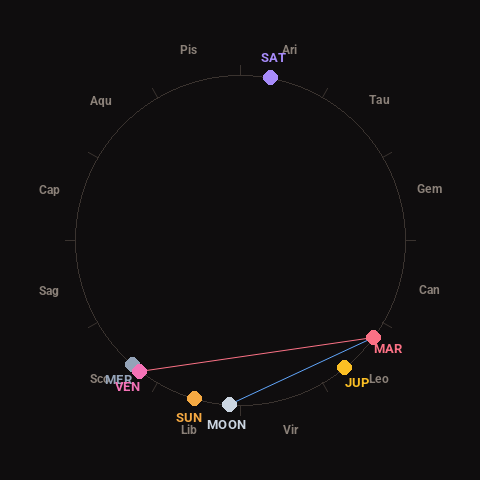
Moon: New Moon (1% illuminated), in Libra.
Notable planetary angles: Venus square Mars (91°), Moon sextile Mars (57°), Mercury conjunct Venus (4°).
Concurrent space weather: planetary Kp index 2.0; strongest recent solar flare: M1.4-class.
This is a factual snapshot, not a claim of cause and effect – researchers are divided on whether lunar, planetary or solar factors influence seismic or weather activity. It’s included so readers can track the pattern for themselves over time.