The National Weather Service office in Greenville-Spartanburg, SC, issued a Flash Flood Warning early Saturday morning, October 11, at 5:11 AM EDT. The warning remains in effect until 11:00 AM EDT and covers 13 areas, including Buncombe, Henderson, Polk, Rutherford, and Avery counties in North Carolina, and Greenville and Spartanburg counties in South Carolina.
A Flash Flood Warning means flooding is happening now or is imminent – this is a step above a watch. Heavy rain falling on already-saturated ground can cause creeks, streams, and poor-drainage areas to rise quickly, sometimes within minutes. Readers in the warned areas may notice rapidly rising water on roads, water covering low-lying spots and underpasses, and small streams running high and fast.
What to do right now
The most important rule: never drive or walk through floodwater. Six inches of moving water can knock an adult down, and a foot of water can float most vehicles. If a road is covered, turn around – you cannot tell how deep the water is or whether the road underneath has washed out.
If you live near a creek, in a low-lying area, or in a basement apartment, be ready to move to higher ground quickly. Keep your phone charged and volume up so you receive any follow-up emergency alerts. Avoid walking near swollen streams, and keep children and pets well away from floodwater, which can be contaminated and hide debris or open holes.
The warning currently runs until 11:00 AM EDT, but it may be extended if heavy rain continues, so keep monitoring local conditions through the morning even after the heaviest rain appears to pass.
This alert is based on the Flash Flood Warning issued by the National Weather Service (NWS) Greenville-Spartanburg office.
Frequently Asked Questions
What should I do right now if I'm in the warned area?
Stay off the roads if possible, and never drive through standing or moving water. If you're near a creek or low spot, be ready to move to higher ground on short notice.
How long will this warning last?
The current warning runs until 11:00 AM EDT on October 11, but NWS may extend it or issue new warnings if rain continues.
Is it safe to drive if the road only looks slightly covered?
No. You can't judge water depth or whether the pavement underneath is intact. Turn around and find another route.
What's the difference between a watch and a warning?
A watch means conditions are favorable for flooding; a warning means flooding is occurring or imminent. This is a warning, so act now rather than waiting.
Keep tracking this:
Source: National Weather Service (NWS)
Related Reading
- Emergency Communication: Staying Connected When Towers Go Down
- Earthquake Survival: Precautions, Kit & Early Warning in 2026
- Essential Guide to Preparing for a Nuclear War
Sky & Solar Conditions at the Time
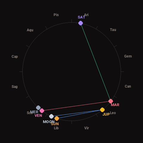
Moon: New Moon (0% illuminated), in Libra.
Notable planetary angles: Venus square Mars (90°), Moon sextile Jupiter (63°), Mars trine Saturn (117°), Sun sextile Jupiter (57°).
Concurrent space weather: planetary Kp index 2.7; strongest recent solar flare: nothing notable.
This is a factual snapshot, not a claim of cause and effect – researchers are divided on whether lunar, planetary or solar factors influence seismic or weather activity. It’s included so readers can track the pattern for themselves over time.