Hurricane Isaias has left a trail of damage along the U.S. East Coast, knocking out power to hundreds of thousands of customers and causing at least four deaths, according to initial reports. The storm made landfall in Florida before continuing north along the Atlantic seaboard, bringing destructive winds, heavy rain, and downed trees and power lines.
If you live in the affected areas, you may notice outages that are widespread and prolonged rather than brief flickers. Fallen trees and snapped power poles can block roads, disable traffic signals, and cut off phone or internet service in some neighborhoods. Utilities typically must wait for winds to drop below safe levels before sending repair crews into the field, which means restoration can take days in the hardest-hit spots, even after the storm itself has moved on.
Those most affected are residents and businesses along Isaias’s path from Florida up the East Coast, where the combination of saturated ground and strong winds brought trees down onto lines and homes. Travelers should expect road closures, debris, and possible flight disruptions at regional airports.
What to keep in mind
Treat all downed lines as live. Stay well away from fallen wires and report them to your utility. Do not drive through flooded roads – it takes only a small amount of moving water to sweep a vehicle away.
Use generators safely. Never run a generator indoors or in a garage; carbon monoxide poisoning is one of the leading causes of storm-related deaths after hurricanes. Keep refrigerators and freezers closed to preserve food as long as possible.
Stay informed on restoration estimates. Check your local utility’s outage map for your specific area, and keep phones charged and flashlights handy rather than candles to reduce fire risk.
This alert is based on storm and damage reporting from the National Weather Service and National Hurricane Center, alongside utility outage reports from affected regions.
Frequently Asked Questions
How long until power is restored?
Restoration times vary widely: crews must wait for safe wind conditions, and areas with downed poles and trees can take several days. Check your local utility's outage map for estimates specific to your neighborhood.
Is this outage connected to space weather or a geomagnetic storm?
No. These outages were caused directly by Hurricane Isaias's winds bringing down trees, lines, and power poles – there is no space-weather component to this event.
Is it safe to drive around now that the storm is passing?
Caution is still needed: many roads are blocked by fallen trees, debris, and standing water, and traffic signals may be dark. Treat non-working signals as four-way stops and never drive through floodwater.
Could more outages happen as the storm moves north?
Yes. As Isaias tracks up the East Coast, additional communities in its path may see outages from strong winds and saturated soil toppling trees onto power lines.
Keep tracking this:
Source: Watching the world evolve and transform
Related Reading
Sky & Solar Conditions at the Time
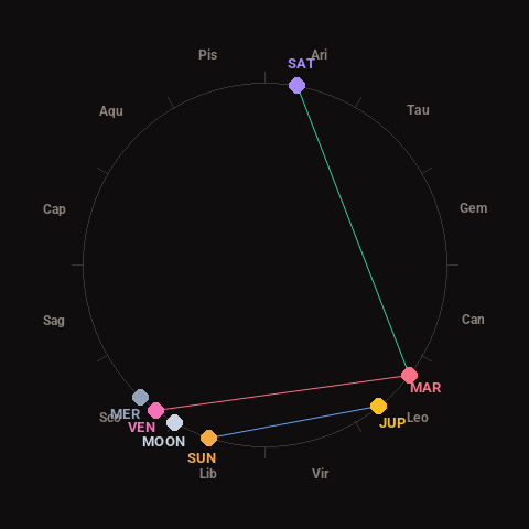
Moon: New Moon (1% illuminated), in Libra.
Notable planetary angles: Venus square Mars (89°), Mars trine Saturn (117°), Sun sextile Jupiter (57°).
Concurrent space weather: planetary Kp index 2.3; strongest recent solar flare: nothing notable.
This is a factual snapshot, not a claim of cause and effect – researchers are divided on whether lunar, planetary or solar factors influence seismic or weather activity. It’s included so readers can track the pattern for themselves over time.