The National Weather Service office in Midland/Odessa, Texas has issued a Flash Flood Warning for Brewster County in West Texas. The warning was issued at 10:02 PM CDT on October 13 and remains in effect until 2:00 AM CDT on October 14.
A Flash Flood Warning means flooding is happening now or is expected to begin very shortly. This is a step above a watch – it means the threat is real and immediate, typically triggered by heavy rain falling faster than the ground or drainage can absorb it.
What This Means on the Ground
Brewster County is a large, rural county in the Big Bend region of West Texas, home to communities like Alpine, Marathon, and Study Butte, as well as Big Bend National Park. Residents and travelers in the area may notice rapidly rising water in normally dry creek beds (arroyos), water flowing over low-water crossings and rural roads, and fast-moving runoff from desert terrain, which does not absorb heavy rain well. Desert regions are especially prone to flash flooding because hard, dry soil sheds water quickly into channels.
Because this warning covers the overnight hours, the risk is elevated – floodwater is much harder to see in the dark, and people may be caught off guard while sleeping or driving late.
Practical steps for those in the warned area:
1. Never drive through flooded roads. Just six inches of moving water can knock a person down, and two feet can carry away most vehicles. Turn around, don’t drown – this applies especially to low-water crossings common in Brewster County.
2. Move to higher ground if you are in a low-lying area, near a creek, arroyo, or in a campsite or RV near a wash. Campers in and around Big Bend should be especially alert to rising water overnight.
3. Keep a phone charged and weather alerts enabled through the remainder of the warning period in case the warning is extended or expanded to nearby areas.
This information comes from the National Weather Service (NWS) office in Midland/Odessa, Texas, part of NOAA.
Frequently Asked Questions
What should I do right now if I'm in Brewster County?
Stay off flooded roads and low-water crossings, and move to higher ground if you are near a creek, arroyo, or low-lying area. Keep weather alerts on in case the warning is extended past 2:00 AM.
How long will this warning last?
The warning is currently in effect until 2:00 AM CDT on October 14. NWS Midland/Odessa may extend, expand, or cancel it early depending on how rainfall and flooding develop.
I'm camping in or near Big Bend – am I at risk?
Yes, desert washes and arroyos in the Big Bend region can fill with fast-moving water within minutes, even if rain is falling miles upstream. Move away from dry creek beds and low campsites immediately.
Can I drive through water covering the road if it looks shallow?
No. It is nearly impossible to judge water depth, especially at night, and just two feet of moving water can sweep away most vehicles. Find an alternate route or wait for the water to recede.
Keep tracking this:
Source: National Weather Service (NWS)
Related Reading
- Emergency Communication: Staying Connected When Towers Go Down
- Earthquake Survival: Precautions, Kit & Early Warning in 2026
- Essential Guide to Preparing for a Nuclear War
Sky & Solar Conditions at the Time
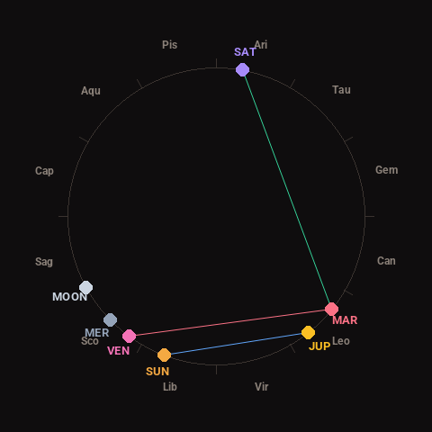
Moon: Waxing Crescent (12% illuminated), in Sagittarius.
Notable planetary angles: Sun sextile Jupiter (59°), Mars trine Saturn (119°), Venus square Mars (87°).
Concurrent space weather: planetary Kp index 2.3; strongest recent solar flare: nothing notable.
This is a factual snapshot, not a claim of cause and effect – researchers are divided on whether lunar, planetary or solar factors influence seismic or weather activity. It’s included so readers can track the pattern for themselves over time.