Walker North Road is closed in both directions just north of Hodges Lane after a tree fell across the roadway, blocking all lanes. The closure was reported today, and drivers should treat the area as fully impassable until crews clear the debris and confirm the road is safe to reopen.
Fallen-tree closures like this one are most often caused by saturated soil, strong winds, or a dead or weakened tree giving way. In some cases, a downed tree can also bring power lines or utility poles down with it, which extends cleanup time and adds hazards for crews and anyone nearby.
What drivers might notice
Expect barricades or flaggers at or near the intersection with Hodges Lane, with traffic being turned back or detoured onto local side streets. Commuters who use Walker North Road as a through route should plan extra travel time, as neighborhood roads around the closure may see heavier-than-normal traffic while the main route is shut down.
Anyone living within the immediate closure area may still be able to reach their homes via one end of the road, but through traffic is not getting past the blockage. If the tree brought down power or communications lines, nearby residents could also experience an outage or spotty service until repairs are made.
Sensible steps for now: avoid the area entirely and use an alternate route rather than driving up to the barricades; check local traffic apps or your county road department’s updates for a reopening estimate; and never approach or drive around a downed tree, since it may be entangled with live power lines or be unstable and shift without warning.
Road closure information in alerts like this comes from local transportation and emergency management reports; weather conditions contributing to downed trees are tracked by the National Weather Service (NWS).
Frequently Asked Questions
Is Walker North Road completely impassable?
Yes – the road is closed in both directions just north of Hodges Lane, so there is no through route past the fallen tree. Residents inside the closure may have local access from one side, but no one can drive through the blockage.
How long will the closure last?
No official reopening time has been given. Clearing a single tree typically takes a few hours, but if utility lines are involved or the pavement was damaged, the closure could extend into the day or longer.
Is it safe to walk up and look at the downed tree?
No – stay clear of the scene. Downed trees can be tangled with live power lines or be under tension and shift suddenly, which is why crews keep the area barricaded.
Could this affect my power or internet?
Possibly. If the tree struck utility lines when it fell, homes near Walker North Road and Hodges Lane could see an outage until repairs are completed – check with your local utility for outage status.
Keep tracking this:
Source: WBRZ
Related Reading
Sky & Solar Conditions at the Time
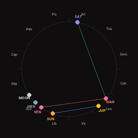
Moon: Waxing Crescent (10% illuminated), in Scorpio.
Notable planetary angles: Sun sextile Jupiter (59°), Mars trine Saturn (118°), Venus square Mars (87°).
Concurrent space weather: planetary Kp index 2.3; strongest recent solar flare: nothing notable.
This is a factual snapshot, not a claim of cause and effect – researchers are divided on whether lunar, planetary or solar factors influence seismic or weather activity. It’s included so readers can track the pattern for themselves over time.