The National Weather Service office in Pueblo, Colorado, has issued a Flood Warning covering 28 areas across southern Colorado and into eastern Utah. The warning was issued on October 22 at 10:07 PM MDT and remains in effect until October 23 at 11:00 AM MDT.
A Flood Warning means flooding is already happening or is about to happen — this is a step above a watch. Among the areas included are Mineral, Rio Grande, Saguache, La Plata, Conejos, Archuleta, Hinsdale, San Miguel, and Montezuma counties in Colorado, along with San Juan County in Utah and 18 additional areas in the region.
What You Might Notice
Residents in affected areas may see fast-rising water in creeks, rivers, and normally dry washes, as well as water over low-lying roads and poor-drainage spots in towns. This part of Colorado and Utah includes steep mountain terrain, where runoff can move quickly into valleys and canyons. Flash flooding can occur with little warning in these areas, and water can rise much faster at night when it’s harder to see.
Anyone traveling through the San Juan Mountains or along rural roads in the warned counties should be prepared for water-covered roadways, mud and debris, and possible closures.
Watch items and preparedness pointers:
1. Never drive through flooded roads. Just six inches of moving water can knock a person down, and about a foot of water can carry away a small vehicle. If you come across a flooded road, turn around and find another route.
2. If you live near a creek, arroyo, or low-water crossing, be ready to move to higher ground quickly, especially overnight. Keep your phone charged so you can receive emergency alerts.
3. Check road conditions before traveling in the region tomorrow morning, and delay trips through mountain passes or canyon roads if water is still high.
This information comes from the National Weather Service office in Pueblo, Colorado, part of NOAA’s National Weather Service.
Frequently Asked Questions
What should I do right now if I'm in one of the warned counties?
Move away from creeks, rivers, and low-lying areas, and avoid driving overnight unless necessary. Keep a phone or weather radio on so you can receive any updated warnings from NWS Pueblo.
How long will this flooding threat last?
The warning is currently in effect until 11:00 AM MDT on October 23, though the National Weather Service may extend, expand, or cancel it as conditions change.
Is it safe to drive through the affected areas?
Only if roads are confirmed clear — never drive through water covering a roadway, since depth and road damage are hard to judge, especially at night. Check local road reports before traveling through southern Colorado or eastern Utah.
Does a Flood Warning mean my home will flood?
Not necessarily — it means flooding is occurring or imminent somewhere in the warned areas, often focused on streams, washes, and poor-drainage zones. If you're on higher ground away from waterways, your risk is lower, but stay alert for updates.
Keep tracking this:
Source: National Weather Service (NWS)
Related Reading
- Emergency Communication: Staying Connected When Towers Go Down
- Earthquake Survival: Precautions, Kit & Early Warning in 2026
- Essential Guide to Preparing for a Nuclear War
Sky & Solar Conditions at the Time
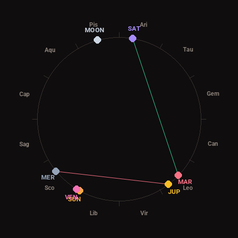
Moon: Waxing Gibbous (86% illuminated), in Pisces.
Notable planetary angles: Mercury square Jupiter (88°), Sun conjunct Venus (2°), Mars trine Saturn (124°).
Concurrent space weather: planetary Kp index 1.7; strongest recent solar flare: nothing notable.
This is a factual snapshot, not a claim of cause and effect – researchers are divided on whether lunar, planetary or solar factors influence seismic or weather activity. It’s included so readers can track the pattern for themselves over time.