The National Weather Service office in Pueblo, Colorado has issued a Flood Warning covering 22 areas across the Four Corners region, including parts of southern Colorado, northern New Mexico, and southern Utah. The warning was issued early this morning, October 25 at 1:19 AM MDT, and remains in effect until 1:15 PM MDT today — roughly a 12-hour window.
Among the confirmed areas under the warning are Conejos, Mineral, Rio Grande, Alamosa, and Montezuma counties in Colorado; San Juan, Cibola, and Valencia counties in New Mexico; and San Juan and Kane counties in Utah, plus a dozen additional areas. A Flood Warning means flooding is already occurring or is imminent — this is more serious than a Flood Watch, which only means conditions are favorable.
Residents in these areas may notice rapidly rising water in creeks, arroyos, and normally dry washes, as well as water over roads, especially at low-water crossings. In the desert Southwest, flash flooding can happen far from where rain is actually falling, since runoff travels quickly downstream through canyons and dry streambeds. Urban poor-drainage areas and burn-scar terrain from recent wildfires are especially prone to fast runoff.
What to keep in mind
If you live or are traveling in the affected areas, a few sensible steps apply. First, never drive through water covering a road — even a foot of moving water can carry away a vehicle, and the roadbed underneath may be washed out. Second, avoid hiking or camping in slot canyons, arroyos, or near streambeds today, as these can flood with little warning even under clear skies overhead. Third, keep an eye on local alerts through the morning and early afternoon, since the warning may be extended or additional warnings issued if heavy rain continues upstream.
This warning covers a wide, mostly rural region, so not every community within the listed counties will see flooding. The most likely trouble spots are low-lying areas near rivers and washes, mountain canyon roads, and known flood-prone crossings. Conditions should begin improving after the warning expires at 1:15 PM MDT, though runoff in streams and rivers can remain elevated for hours afterward.
Data for this alert comes from the National Weather Service (NWS) office in Pueblo, Colorado.
Frequently Asked Questions
What's the difference between a Flood Warning and a Flood Watch?
A Flood Warning means flooding is happening now or is imminent in the warned areas. A Watch only means conditions are favorable for flooding — a Warning calls for immediate caution, especially around roads and waterways.
What should I do right now if I'm in one of these areas?
Avoid driving through any water-covered roadway, stay clear of arroyos, washes, and canyon bottoms, and move to higher ground if water rises near your home. Keep monitoring local NWS updates until the warning expires at 1:15 PM MDT.
How long will this flooding risk last?
The current warning runs until 1:15 PM MDT on October 25, though it could be extended if heavy rain continues. Streams and rivers may also stay high for several hours after the rain ends.
Is it safe to travel through Colorado, New Mexico, or Utah today?
Travel is possible but requires caution — check road conditions before departing, expect possible closures at low-water crossings, and never attempt to cross flooded roads. Mountain and canyon routes in the warned counties carry the highest risk today.
Keep tracking this:
Source: National Weather Service (NWS)
Related Reading
- Emergency Communication: Staying Connected When Towers Go Down
- Earthquake Survival: Precautions, Kit & Early Warning in 2026
- Essential Guide to Preparing for a Nuclear War
Sky & Solar Conditions at the Time
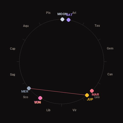
Moon: Waxing Gibbous (94% illuminated), in Aries.
Notable planetary angles: Sun conjunct Venus (0°), Mercury square Jupiter (88°).
Concurrent space weather: planetary Kp index 0.3; strongest recent solar flare: nothing notable.
This is a factual snapshot, not a claim of cause and effect – researchers are divided on whether lunar, planetary or solar factors influence seismic or weather activity. It’s included so readers can track the pattern for themselves over time.