The U.S. State Department has raised its travel advisory for Gaza to Level 4: Do Not Travel — the highest warning level on its four-tier scale. The escalation cites terrorism, civil unrest, and severely limited health infrastructure as the driving factors.
Under this advisory, U.S. government employees are prohibited from traveling to Gaza for any reason due to safety risks. The State Department also notes it is unable to provide routine or emergency consular services to U.S. citizens in Gaza, meaning Americans who travel there would be largely on their own if something goes wrong.
The advisory summary states that terrorist groups, lone-actor terrorists, and other violent extremists continue plotting possible attacks in Gaza. Combined with unrest and a health system under extreme strain, officials say the risk environment makes any travel to the territory dangerous.
What this means for everyday readers
For most readers, this advisory changes nothing about daily life in the United States — it is a travel restriction, not a domestic threat alert. The people most directly affected are U.S. citizens with family, aid work, journalism assignments, or other ties to Gaza, as well as humanitarian organizations coordinating travel into the region. If you have flights or connections through the broader region, check with your airline, as itineraries near Israel and neighboring areas can shift on short notice during periods of escalation.
Practical watch-items:
1. If you know a U.S. citizen currently in Gaza, encourage them to enroll in the State Department’s Smart Traveler Enrollment Program (STEP) and to review departure options while they remain available.
2. If you have travel booked to Israel, the West Bank, or nearby countries, monitor those advisories separately — each carries its own level and conditions can change quickly.
3. Expect heightened security measures at airports and border crossings in the surrounding region, and build extra time into any affected travel plans.
This advisory information comes from the U.S. Department of State’s official travel advisory system.
Frequently Asked Questions
What does Level 4 actually mean?
Level 4 is the State Department's highest travel advisory tier, instructing U.S. citizens not to travel to the location under any circumstances due to life-threatening risks.
Can the U.S. government help Americans already in Gaza?
The State Department states it cannot provide routine or emergency consular services in Gaza, so Americans there have very limited official assistance options.
Does this advisory affect travel to Israel or other nearby countries?
This advisory covers Gaza specifically; Israel and neighboring countries have their own separate advisory levels, so travelers should check each destination individually before booking or departing.
Is this advisory a sign of danger to people in the United States?
No — this is a travel warning for Gaza, not a domestic threat alert, and it does not indicate any change to safety conditions inside the U.S.
Keep tracking this:
Source: U.S. Department of State
Related Reading
Sky & Solar Conditions at the Time
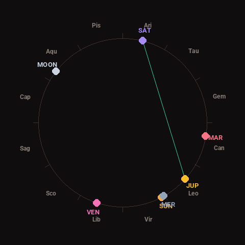
Moon: Waxing Gibbous (95% illuminated), in Aquarius.
Notable planetary angles: Jupiter trine Saturn (118°), Sun conjunct Mercury (2°).
Concurrent space weather: planetary Kp index 0.3; strongest recent solar flare: nothing notable.
This is a factual snapshot, not a claim of cause and effect – researchers are divided on whether lunar, planetary or solar factors influence seismic or weather activity. It’s included so readers can track the pattern for themselves over time.