The National Weather Service office in New Orleans issued a Tropical Storm Warning on October 8 at 4:13 PM CDT covering 68 areas across southeast Louisiana, coastal Mississippi, and parts of west-central Alabama. A Tropical Storm Warning means tropical-storm-force winds – sustained winds of 39 to 73 mph – are expected within the warned area, generally within the next 36 hours.
The warning zone includes the metro New Orleans area (Eastern Orleans), Lower Plaquemines and Lower St. Bernard parishes, Southeast St. Tammany, and the Mississippi coastal counties of Hancock, Harrison, and Jackson, stretching inland to areas such as Marengo County, Alabama.
What Residents Might Notice
Expect strengthening winds, heavy bands of rain, and rough surf along the coast. Coastal communities in Lower Plaquemines and Lower St. Bernard should be alert for minor to moderate coastal flooding and high water on low-lying roads. Scattered power outages are possible as winds knock down tree limbs and power lines. Ferry, causeway, and bridge travel – including the Lake Pontchartrain Causeway – may face restrictions as winds increase.
Practical steps to take now:
1. Secure outdoor items. Bring in or tie down patio furniture, trash cans, and anything that could become airborne in 40-70 mph gusts.
2. Charge devices and fuel up. Top off phone batteries, vehicle gas tanks, and any generator fuel before conditions deteriorate tonight.
3. Avoid coastal and low-lying roads during periods of heavy rain or high tide, and never drive through standing water.
This is a standard tropical storm threat, not a major hurricane situation, but conditions can still be hazardous – especially on the water and along the immediate coast. Monitor local NWS updates for any changes to the storm’s track or intensity.
Data source: National Weather Service (NWS) New Orleans, Louisiana, in coordination with NOAA’s National Hurricane Center.
Frequently Asked Questions
What should I do right now if I'm in the warning area?
Secure loose outdoor items, charge your phone and devices, and make sure you have water, medications, and flashlights ready in case of power outages. Avoid unnecessary travel once winds pick up, especially over bridges and coastal roads.
How long will this warning last?
Tropical Storm Warnings typically remain in effect until the storm's strongest winds pass, usually within 24-48 hours of issuance. NWS New Orleans will update or cancel the warning as the system moves through.
Will there be flooding in New Orleans and the coastal parishes?
Heavy rain bands could cause street flooding in low-lying areas, and minor to moderate coastal flooding is possible in Lower Plaquemines, Lower St. Bernard, and the Mississippi coast. Do not drive through flooded roads.
Is this storm expected to become a hurricane?
The current warning is for tropical-storm-force winds (39-73 mph). If the system strengthens, NWS would upgrade the alert – keep monitoring official updates from the National Hurricane Center for any changes.
Keep tracking this:
Source: National Weather Service (NWS)
Related Reading
- Emergency Communication: Staying Connected When Towers Go Down
- Earthquake Survival: Precautions, Kit & Early Warning in 2026
- Essential Guide to Preparing for a Nuclear War
Sky & Solar Conditions at the Time
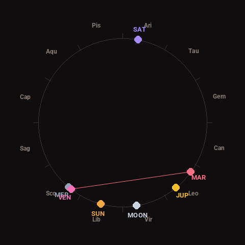
Moon: Waning Crescent (5% illuminated), in Virgo.
Notable planetary angles: Venus square Mars (92°), Mercury conjunct Venus (2°).
Concurrent space weather: planetary Kp index 2.0; strongest recent solar flare: M6.7-class.
This is a factual snapshot, not a claim of cause and effect – researchers are divided on whether lunar, planetary or solar factors influence seismic or weather activity. It’s included so readers can track the pattern for themselves over time.