The U.S. State Department has raised its travel advisory for Gaza to Level 4: Do Not Travel, the highest warning level on the department’s four-tier scale. The advisory cites terrorism, civil unrest, and severely limited health infrastructure as the reasons for the escalation. Level 4 means the U.S. government is advising all Americans to avoid the area entirely and urging anyone already there to consider departing if they can do so safely.
There are several practical details in this advisory worth understanding. U.S. government employees are now prohibited from traveling to Gaza for any reason due to safety risks. The State Department also warns that terrorist groups, lone actors, and other violent extremists continue to plot possible attacks in the territory. Critically, the U.S. government states it is unable to provide routine or emergency consular services to American citizens in Gaza — meaning that if a U.S. citizen there runs into trouble, there is no embassy assistance available to help them.
Who Is Affected
This advisory applies to all U.S. citizens and lawful permanent residents considering travel to Gaza. It is especially relevant to journalists, humanitarian and aid workers, people with family in the region, and anyone planning travel through nearby border crossings. Airlines, tour operators, and insurance providers also use these levels to shape coverage and itineraries, so travelers to the broader region may see ripple effects in flight options, trip insurance terms, and employer travel policies.
If you have travel planned anywhere in the region, here are sensible steps to take now:
1. Check the current advisory level for every country on your itinerary — neighboring areas may carry their own warnings, and levels can change quickly. 2. Enroll any upcoming international travel in the State Department’s Smart Traveler Enrollment Program (STEP) so the nearest embassy can reach you in an emergency. 3. Review your travel insurance and evacuation coverage, since many policies exclude destinations under Level 4 advisories, and confirm alternative routes in case regional airspace or border crossings close.
This advisory is a warning, not a prediction — it reflects conditions on the ground and the government’s limited ability to assist. Travelers already in the broader region should stay in contact with family, keep documents accessible, and monitor official updates.
Advisory information comes from the U.S. Department of State’s Bureau of Consular Affairs.
Frequently Asked Questions
What does Level 4 actually mean?
Level 4 is the State Department's highest travel warning, instructing U.S. citizens not to travel to the destination for any reason. In Gaza's case, it reflects risks from terrorism, unrest, and very limited health infrastructure.
Can the U.S. government help me if I'm already in Gaza?
No. The State Department states it cannot provide routine or emergency consular services in Gaza, and U.S. government employees are barred from traveling there. Americans in Gaza should depart if they can do so safely.
Does this affect travel to other parts of the region?
This advisory is specific to Gaza, but neighboring destinations carry their own advisory levels, which you should check individually before traveling. Regional airspace or border changes can also affect flights beyond Gaza itself.
Will my travel insurance cover a trip to a Level 4 destination?
Most standard travel insurance policies exclude coverage for Level 4 destinations, and medical evacuation coverage may not apply. Contact your insurer directly to confirm what your policy does and does not cover.
Keep tracking this:
Source: U.S. Department of State
Related Reading
Sky & Solar Conditions at the Time
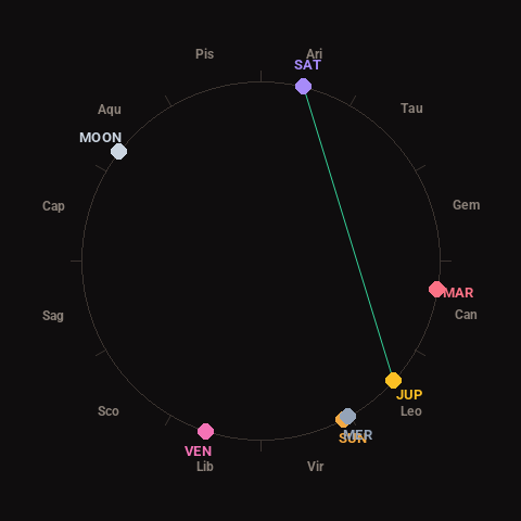
Moon: Waxing Gibbous (95% illuminated), in Aquarius.
Notable planetary angles: Jupiter trine Saturn (118°), Sun conjunct Mercury (2°).
Concurrent space weather: planetary Kp index 0.3; strongest recent solar flare: nothing notable.
This is a factual snapshot, not a claim of cause and effect – researchers are divided on whether lunar, planetary or solar factors influence seismic or weather activity. It’s included so readers can track the pattern for themselves over time.