The Lhende Collapse
A slab of ice fell 1,200 metres, dammed a border river, and then let go. Thirty minutes later the Trishuli was nine metres higher and two valleys had stopped existing.
Situation summary
Status: ongoing. A barrier lake formed by the collapse debris is still filling and Chinese water authorities expect roughly three million additional cubic metres to arrive over the next three days. Rain is forecast. Downstream districts remain under evacuation advisory. Caution: casualty figures are moving hourly and different agencies are counting differently. See the note below the toll table.
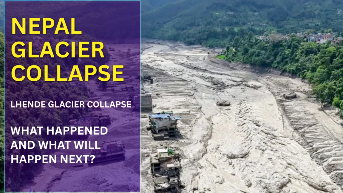
At 8:37 on the morning of 26 August, seismometers across the Himalaya registered a magnitude 5.2 event roughly 55 kilometres northwest of Kodari, on the Nepal–China border. The first bulletins called it an earthquake. It was not an earthquake. It was the sound of a mountain losing a piece of itself: a mass of ice and rock detaching at around 5,200 metres and falling some 1,200 metres onto the headwaters of the Lhende Khola, a small border river that almost nobody outside Rasuwa district had ever heard of.
Three minutes later, the water arrived at Rasuwagadhi.
Horrible video of Nepal flood
· Preeti Sompura (@sompura_preeti) August 26, 2026
What followed is now, by confirmed toll, the deadliest single mountain-hazard event the central Himalaya has recorded in living memory: 392 dead across Nepal and Tibet as of Friday morning, close to 1,500 people missing, and a corridor of destruction running from the Gyirong border crossing in Tibet down through Timure and Syabrubesi in Nepal and out into the Trishuli valley. Among the missing are several hundred foreign nationals. Trekkers heading into Langtang, pilgrims on the Kailash Mansarovar route, and truck drivers queued at what is Nepal’s most important overland trade gate with China.
The uncomfortable part, and the reason this belongs on a preparedness site rather than only on a news wire, is that the mechanism behind it is neither exotic nor unprecedented. It is becoming routine.
What actually happened on the mountain
The sequence needs to be separated into two distinct disasters, because they had different physics and, crucially, different warning windows.
The first was a rock-ice avalanche. A section of glacier, its volume still being estimated from satellite passes, separated from its bed high on the Tibetan side of the divide and ran down the slope, picking up rock, moraine and saturated sediment as it went. Landslide researcher Dave Petley, who has been reading the seismic traces publicly since Wednesday, was among the first to point out that the signal had the long, messy, low-frequency character of a mass movement rather than the sharp onset of a tectonic rupture. The USGS subsequently revised its interpretation: the seismic energy was generated by the landslide itself, not by an earthquake that caused it.
That distinction matters more than it sounds. If the trigger had been a quake, the collapse would be a secondary effect of something we already monitor closely. Because it was not, the collapse was, on the evidence available so far, spontaneous. Nothing shook the slope loose. The slope simply stopped holding.
The second disaster was the dam break. The avalanche debris hit the Lhende Khola and blocked it. Water ponded behind the blockage for a short period, then overtopped and cut through it. Where the volume came from is still genuinely open: Petley has suggested a combination of ice converted to meltwater by the sheer energy of the collapse, water already held in the saturated sediments that were mobilised, and the impounded river itself. Whatever the ratio, the outflow was not water in the ordinary sense. It was a debris flow: mud, boulders, ice blocks and shredded forest moving as a single dense mass, which is why it took out reinforced concrete bridges that ordinary flood water would have passed under.
A first indication of scale came from Landsat 9. Robert Rohde of Berkeley Earth, working from the satellite’s unusually clear pass over the site, put the failed area at roughly one square kilometre of ice and rock, while stressing that this is a rough estimate read off imagery rather than a surveyed figure. One square kilometre of mountainside, leaving at once.
Landsat 9 captured very clear images of the Himalayan glacier that collapsed, triggering the catastrophic flash floods in Nepal. Estimating very roughly from these images, it appears that the area that failed may have spanned ~1 km² of ice and rock.
· Dr. Robert Rohde (@RARohde) August 27, 2026
Thirty minutes
The single most important number in this entire event is not the death toll. It is nine metres in thirty minutes, the recorded rise on the Trishuli at one gauge point. Nine metres is roughly a three-storey building. Thirty minutes is less time than most people take to decide whether something is serious.
Consider what that window actually contains for someone standing in Syabrubesi. There is no siren, because there is no early-warning system on the Lhende Khola. There was no glacial lake there to monitor, which is precisely why nobody was watching it. There is no upstream phone call, because the villages upstream were hit first and their towers went with them. The first indication most people had was noise: a low, sustained roar that witnesses have consistently described as sounding wrong for a river. By the time the sound is identifiable, the useful part of the window is already spent.
Every video emerging from Nepal is somehow even scarier than the last. A peaceful valley under a bright, completely normal sky and then suddenly look at how that wall of gushing water sweeps away everything in its path.
· Nikhil Saini (@iNikhilsaini) August 26, 2026
The infrastructure loss reflects that speed. At least nineteen bridges are gone. Roughly forty kilometres of road has been erased rather than damaged, including sections of the corridor that connects Kathmandu to the Chinese border. Hydropower projects along the Bhotekoshi and Trishuli, several of them recently commissioned, have been hit; transmission lines are down; the Prithvi Highway was blocked. Nepal has spent fifteen years building generation capacity in exactly these steep, water-rich valleys, and this event has demonstrated the obvious corollary of that strategy in a single morning.
La inundación de Nepal se llevó por delante una represa entera.
· ElBuni (@therealbuni) August 26, 2026
The toll, and why the numbers disagree
| Category | Nepal | Tibet (China) | Total |
|---|---|---|---|
| Confirmed dead | 389 | 3 | 392 |
| Reported missing | ~910 | 558 | ~1,470 |
| Foreign nationals missing | ~600 | ~260 | ~800 |
| Rescued | n/a | 466 | |
| Bridges destroyed | n/a | 19+ | |
| Road destroyed | n/a | ~40 km | |
Rasuwa is a small district carrying an unusually heavy transient population. It is the trailhead for Langtang, one of Nepal’s three most-walked trekking regions; it is the road to the Kailash Mansarovar pilgrimage, which draws Indian pilgrims in large organised groups through exactly this season; and Rasuwagadhi is the primary functioning land-trade gate to China, which means a permanent queue of freight trucks and their drivers on both sides of the border. Late August put all three populations in the valley at once, in the morning, on the road. That is the arithmetic behind the foreign-national numbers.
The sheer scale of the flash flood in Nepal is INSANE!! And this is from above the clouds. People didn’t stand a chance.
· Mario Nawfal (@MarioNawfal) August 26, 2026
The response has been fast and unusually joint. Nepal has more than thirteen thousand military and police personnel deployed with helicopter rescue running wherever cloud allows; 466 people have been pulled out so far. China’s premier arrived on Thursday with several hundred military and paramilitary personnel and an emergency allocation of around $17.9 million. The UN released $2 million from its central emergency fund, and Washington has pledged an initial $500,000. In a region where cross-border disaster cooperation is usually theoretical, the speed of the Chinese deployment is itself notable.
The second flood has not happened yet
This is the part of the story that is still live, and it is the reason nobody downstream should be treating Friday as the aftermath.
The collapse debris did not fully wash out. What remains is a barrier lake: an unengineered dam of loose rock, ice and mud impounding a growing volume of water. Nepal’s disaster management authority has stated plainly that the lake is rising and “is at risk of bursting.” China’s water ministry reports it is already overflowing, with an estimated three million cubic metres of additional inflow expected over three days, and rain is in the forecast.
Landslide dams fail in a characteristic way. They do not leak gently. Water overtops the crest, begins incising a channel through unconsolidated material, and the incision accelerates as flow concentrates, so the dam goes from apparently stable to fully breached over a period measured in minutes to a couple of hours. That is the same mechanism that produced Wednesday’s flood, from the same debris, in the same channel, over a valley whose bridges and escape roads have now been removed and whose population includes thousands of rescuers working on the riverbed.
This is not a freak event, and pretending otherwise is the actual danger
Glacial collapses of this size remain genuinely rare, with only a handful documented worldwide in the past decade. But the trend line under them is not rare at all, and the Himalayan record over the last ten years reads less like a series of accidents than like a pattern establishing itself.
Tibet has become the epicentre. The Aru range in western Tibet produced twin glacier detachments in 2016 that killed nine herders and startled glaciologists, because until then the prevailing view was that low-angle valley glaciers simply did not do that. The Sedongpu gully on the Yarlung Tsangpo produced repeated ice-rock avalanches and river blockages from 2018 onward. A further major collapse followed in 2022. Across the border, the Chamoli disaster in India’s Uttarakhand in February 2021 was the same physics arriving in a different valley: a rock-and-ice avalanche that destroyed two hydropower projects and killed around two hundred people. Nepal itself has had two recent rehearsals: the Thame flood in August 2024, when a moraine-dammed lake above the Khumbu emptied into a village, and the Bhotekoshi flood of July 2025, which came down this same border corridor and destroyed the Friendship Bridge at Rasuwagadhi.
That last one deserves emphasis. Fourteen months ago, a supraglacial lake in Tibet drained into the same river system and wrecked the same border crossing. The corridor had already been given a demonstration. It was rebuilt in place.
The underlying driver is not seriously disputed, even if attribution for this specific slab is not yet possible. Himalayan glaciers lost ice roughly 65% faster in 2011–2020 than in the preceding decade. Nepal’s glaciers have shed close to a third of their volume in thirty years. Permafrost that has been cementing high rock faces together for millennia is thawing, meltwater is pressurising fractures, and slopes that were stable for the whole of recorded human settlement are being asked to hold under conditions they have never held under. As one scientist put it this week, there is high confidence of more heatwaves, more glacial retreat and more permafrost loss in these mountains. That is a technical way of saying the supply of these events is increasing.
Forty-seven lakes with names
The bitter irony of the Lhende collapse is that Nepal actually does this kind of assessment reasonably well. ICIMOD, working with the government and UNDP, has catalogued 47 potentially dangerous glacial lakes across the basins that drain into Nepal: 21 inside Nepal itself, 25 across the border in Tibet, and one in India. Six have been flagged as needing urgent intervention: Lower Barun, Thulagi, Lumding Tsho, Hongu 2 / Chamlang South, Tsho Rolpa and Imja Tsho. Two of those, Tsho Rolpa and Imja, have had engineered lake-lowering work and early-warning installations, which is a real preparedness success and worth saying out loud.
But every one of those 47 entries is a lake. The catalogue exists because the assumed hazard is a lake bursting its moraine. What happened on the Lhende Khola was a dry slope failing and then manufacturing its own flood, a hazard with no reservoir to survey, no water level to telemeter, and therefore no place on the list. You cannot install an early-warning system on a lake that does not exist yet.
This is the structural gap, and it is not unique to Nepal. Hazard registers everywhere are built from the disasters that have already happened. The Himalaya is currently producing disasters that are not yet on the register.
If you live, work or trek below ice
None of what follows would have saved everyone in Syabrubesi on Wednesday morning. Some of it would have saved some of them. That is the honest framing for a hazard with a thirty-minute window. You are not preventing anything, you are buying minutes and using them well.
- 01Know your vertical, not your exit road.In a debris flood the valley road is the flood path, and the bridge you were planning to cross is the first thing to go. The only relevant question is how far up the valley wall you can get and how fast. Walk it once, in daylight, before you need it. Thirty vertical metres of scramble that you have actually done beats a kilometre of road you are hoping is intact.
- 02Treat sound as the alarm.Survivors of Chamoli, Thame and now Rasuwa describe the same thing: a sustained roar, often with a ground vibration, arriving before anything is visible. There is no siren coming. If the river noise changes character and does not stop, move uphill immediately and apologise for overreacting afterwards.
- 03A river that suddenly drops is a warning, not a relief.An upstream blockage starves the channel before it releases. A river running unusually low or muddy for no reason you can see means something is holding it back, and that something will fail. This is one of the few genuinely early signals available, and it is routinely misread.
- 04Camp and sleep above the high-water terrace.Trekking lodges and truck stops cluster on flat ground beside the water because it is flat, and it is flat because the river built it. Anywhere the river built, the river can reclaim. Pay the extra ten minutes of walking to sleep on the older, higher terrace.
- 05Assume communications die with the first wave.Towers in these valleys sit on the same fragile shelves as everything else. Carry a satellite messenger if you are in the high country and, more importantly, leave a written route and a check-in schedule with someone who will actually raise an alarm if you miss it. A large share of Wednesday’s missing are missing partly because nobody knew precisely where they were.
- 06Understand the second-event rule.Barrier lakes are the standard sequel to every one of these collapses. The hours and days after a mountain flood are not the safe window. They are the window in which people go back down to the riverbed to search, salvage and rebuild, and get caught by the follow-up. If a landslide dam is upstream of you, the valley floor stays closed until an authority with instruments says it is open.
What this event is really telling us
Nepal will rebuild the Rasuwagadhi corridor. It has to. That road is the country’s principal overland connection to its northern neighbour, and there is a hydropower build-out and a trade relationship depending on it. It rebuilt the same crossing after July 2025. It will very likely rebuild in the same valley again, because in terrain this steep there is no second alignment to move to.
Which means the real question is not whether the Himalaya will produce another one of these. It is whether the assumptions underneath every road, bridge, powerhouse, lodge and border post in these valleys are still valid, when the slopes above them are being held together by permafrost that is on its way out. Nepal has, to its credit, catalogued its dangerous lakes and drained two of them. Nobody has catalogued the dangerous slopes, because until fairly recently there was no reason to think a glacier could simply let go of a mountainside on a clear morning in August.
There is now.
Media desk
Verified footage and imagery for this story, with the rights holder for each. Nothing here is reproduced on this page. Use the publisher’s own embed where one is offered, and credit as listed.
Reporting sources
- ABC News · New flood warnings issued as death toll rises to 392
- Al Jazeera · What happened, what caused them and who is missing · What is a glacial collapse · Satellite images show the destruction
- EarthSky · Nepal flash flood: what caused it? (USGS revision, Dave Petley analysis)
- OnlineKhabar · 10 things to know about the Rasuwa flood
- Newsweek · Missing toll surpasses 1,000
- Fortune · Casualties and international response
- IANS · 47 glacial lakes pose outburst threat across Nepal’s river corridors