
Last updated November 17, 2026 at 06:30 UTC. This page is updated in place as the situation changes, rather than published as a new article each time.
The National Weather Service office in Corpus Christi, Texas, has issued a Flood Warning effective the evening of November 16 through 8:00 PM CST on November 18. The warning currently covers seven areas: McMullen County in Texas; Lake, Volusia, Seminole, and Brevard Counties in Florida; and Maricopa and Yuma Counties in Arizona.
A Flood Warning means flooding is already occurring or is imminent in the warned areas – this is a step above a Flood Watch, which only means conditions are favorable for flooding. Residents in the affected counties may notice rising water on roads, swollen creeks and drainage channels, and standing water in low-lying spots. Urban flooding is possible where drainage systems are overwhelmed by heavy rain.
What to keep in mind
Never drive through flooded roads. Just six inches of moving water can knock a person down, and about a foot of water can float most vehicles. ‘Turn around, don’t drown’ applies every time – you cannot judge water depth or road condition underneath from the driver’s seat.
Move valuables and vehicles to higher ground if you live in a flood-prone area or near a creek, arroyo, or low-water crossing. This is especially relevant in the Arizona counties, where desert washes can fill quickly and flash flooding can develop fast after rain.
Keep phones charged and alerts enabled. Warnings can be upgraded or extended, and conditions can change overnight. Have a way to receive Wireless Emergency Alerts while you sleep, and know your route to higher ground before you need it.
Most flooding deaths occur in vehicles, and most are preventable. If local officials issue evacuation guidance for your area, follow it promptly rather than waiting to see how bad it gets.
Data for this alert comes from the National Weather Service (NWS), part of NOAA.
Frequently Asked Questions
What should I do right now if I'm in one of these counties?
Avoid driving on flooded or water-covered roads, move away from creeks, washes, and low-water crossings, and make sure your phone can receive emergency alerts. If water is rising near your home, move to higher ground without waiting for an official order.
How long will this Flood Warning last?
The warning is currently in effect until 8:00 PM CST on November 18, though the NWS may extend, expand, or cancel it as conditions change. Check for updated alerts if heavy rain continues in your area.
Why are counties in Texas, Florida, and Arizona all listed together?
The alert feed bundles areas under active flood warnings from the same issuance window, so it covers several separate weather situations at once. What matters is whether your specific county is listed – conditions and rainfall amounts will differ by location.
Is it safe to drive if the water looks shallow?
No – depth is hard to judge, and moving water can sweep a vehicle away in as little as 12 inches. The road surface underneath may also be washed out. Find an alternate route instead.
Update History
Earlier updates on this page, newest first:
- Nov 16, 2026 – Flood Warning – 8 Areas Affected (National Weather Service (NWS))
- Nov 15, 2026 – Flood Warning – 8 Areas Affected (National Weather Service (NWS))
- Nov 14, 2026 – Flood Warning – 7 Areas Affected (National Weather Service (NWS))
- Nov 14, 2026 – Flood Warning – 7 Areas Affected (National Weather Service (NWS))
- Nov 13, 2026 – Flood Warning – 8 Areas Affected (National Weather Service (NWS))
- Nov 12, 2026 – Flood Warning – 8 Areas Affected (National Weather Service (NWS))
- Nov 11, 2026 – Flood Warning – 8 Areas Affected (National Weather Service (NWS))
- Nov 11, 2026 – Flood Warning – 10 Areas Affected (National Weather Service (NWS))
- Nov 10, 2026 – Flood Warning – 12 Areas Affected (National Weather Service (NWS))
- Nov 9, 2026 – Flood Warning – 8 Areas Affected (National Weather Service (NWS))
- Nov 8, 2026 – Flood Warning – 9 Areas Affected (National Weather Service (NWS))
- Nov 8, 2026 – Flood Warning – 9 Areas Affected (National Weather Service (NWS))
- Nov 7, 2026 – Flood Warning – 10 Areas Affected (National Weather Service (NWS))
- Nov 6, 2026 – Flood Warning – 22 Areas Affected (National Weather Service (NWS))
- Nov 5, 2026 – Flood Warning – 27 Areas Affected (National Weather Service (NWS))
- Nov 5, 2026 – Flood Warning – 30 Areas Affected (National Weather Service (NWS))
- Nov 4, 2026 – Flood Warning – 43 Areas Affected (National Weather Service (NWS))
- Nov 3, 2026 – Flood Warning – 28 Areas Affected (National Weather Service (NWS))
- Nov 2, 2026 – Flood Warning – 34 Areas Affected (National Weather Service (NWS))
- Nov 2, 2026 – Flood Warning – 32 Areas Affected (National Weather Service (NWS))
- Nov 1, 2026 – Flood Warning – 7 Areas Affected (National Weather Service (NWS))
- Oct 31, 2026 – Flood Warning – 4 Areas Affected (National Weather Service (NWS))
- Oct 30, 2026 – Flood Warning – 5 Areas Affected (National Weather Service (NWS))
- Oct 30, 2026 – Flood Warning – 3 Areas Affected (National Weather Service (NWS))
- Oct 29, 2026 – Flood Warning – 4 Areas Affected (National Weather Service (NWS))
- Oct 28, 2026 – Flood Warning Covering Parts of Colorado, Florida, and New Mexico Through Early October 29
- Oct 27, 2026 – Flood Warning Issued for 12 Areas Across Colorado, Texas, Florida, and Utah
- Oct 26, 2026 – Flood Warning in Effect Overnight for Parts of Colorado, New Mexico, Utah, Texas, and Florida
- Oct 25, 2026 – Flood Warning Across the Four Corners Region — 22 Areas in CO, NM, UT
- Oct 24, 2026 – Flood Warning: 21 Areas Under Alert Through October 25 Across Multiple States
Keep tracking this:
Source: National Weather Service (NWS)
Related Reading
- Top 10 YouTube Videos on Boarding Up Windows for a Hurricane
- Emergency Communication: Staying Connected When Towers Go Down
- Earthquake Survival: Precautions, Kit & Early Warning in 2026
Sky & Solar Conditions at the Time
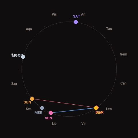
Moon: Waxing Crescent (20% illuminated), in Capricorn.
Notable planetary angles: Mars conjunct Jupiter (1°), Venus sextile Mars (58°), Venus sextile Jupiter (57°), Sun square Mars (87°).
Concurrent space weather: planetary Kp index 0.3; strongest recent solar flare: nothing notable.
This is a factual snapshot, not a claim of cause and effect – researchers are divided on whether lunar, planetary or solar factors influence seismic or weather activity. It’s included so readers can track the pattern for themselves over time.