The National Weather Service office in El Paso, Texas / Santa Teresa, New Mexico issued a Flash Flood Warning early this morning, September 23, at 3:02 AM MDT. The warning remains in effect until 6:00 AM MDT and covers areas including Dona Ana and Otero counties in New Mexico and El Paso, Texas. Additional locations listed under the warning feed include Cumberland, Powhatan, and Amelia counties in Virginia.
A Flash Flood Warning means flooding is already happening or is about to happen – this is more urgent than a watch. In the El Paso and southern New Mexico region, heavy overnight rain can quickly overwhelm desert soils, arroyos, and low-water crossings, sending fast-moving water across roads and into low-lying neighborhoods.
What you might notice
Residents in the warned areas may see rapidly rising water in normally dry washes and arroyos, water covering roadways (especially at low-water crossings), ponding on streets and in yards, and possible mud or debris on roads in steeper terrain. If you are driving overnight in the Borderland region, be alert for barricades and never attempt to drive through flooded roads – it takes only about 12 inches of moving water to carry away a small car.
Who is affected: Communities across El Paso County, TX, and Dona Ana and Otero counties, NM – including the cities of El Paso and Las Cruces – are in the core warning area. Residents in the listed Virginia counties should follow guidance from their local National Weather Service office.
Practical steps right now:
1. Stay off the roads if possible until the warning expires at 6:00 AM MDT, and never drive or walk through moving floodwater. 2. If you live in a low-lying area or near an arroyo, move to higher ground and keep your phone charged with alerts enabled. 3. Monitor local NWS updates, as warnings can be extended if rain continues.
Data for this alert comes from the National Weather Service (NWS) El Paso, TX / Santa Teresa, NM forecast office.
Frequently Asked Questions
What should I do right now if I'm in the warned area?
Stay off the roads and away from arroyos, washes, and low-water crossings until the warning expires at 6:00 AM MDT. If water is rising near your home, move to higher ground immediately.
Is it safe to drive through water covering the road?
No. Turn around – about 12 inches of moving water can sweep away a small vehicle, and floodwater often hides washed-out pavement underneath.
How long will this warning last?
The warning is currently set to expire at 6:00 AM MDT on September 23, but the NWS can extend or reissue it if heavy rain continues.
Why are Virginia counties listed alongside Texas and New Mexico?
The warning feed covers multiple separate areas. The core threat is in the El Paso / southern New Mexico region; Virginia residents should follow their own local NWS office for details.
Keep tracking this:
Source: National Weather Service (NWS)
Related Reading
- Emergency Communication: Staying Connected When Towers Go Down
- Earthquake Survival: Precautions, Kit & Early Warning in 2026
- Essential Guide to Preparing for a Nuclear War
Sky & Solar Conditions at the Time
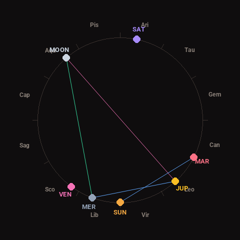
Moon: Waxing Gibbous (88% illuminated), in Aquarius.
Notable planetary angles: Moon trine Mercury (120°), Moon opposite Jupiter (179°), Mercury sextile Jupiter (62°), Sun sextile Mars (63°).
Concurrent space weather: planetary Kp index 0.3; strongest recent solar flare: nothing notable.
This is a factual snapshot, not a claim of cause and effect – researchers are divided on whether lunar, planetary or solar factors influence seismic or weather activity. It’s included so readers can track the pattern for themselves over time.