The National Weather Service office in Tampa Bay/Ruskin has issued a Flash Flood Warning for Hillsborough and Pinellas counties in west-central Florida. The warning was issued at 9:14 PM EDT on October 7 and remains in effect until 10:45 PM EDT the same evening.
A Flash Flood Warning means flooding is already occurring or is about to begin shortly – this is more urgent than a watch, which only means conditions are favorable. This warning covers a densely populated part of the Tampa Bay metro area, including the cities of Tampa, St. Petersburg, and Clearwater, along with surrounding communities.
What residents may notice
Heavy rainfall over a short period can quickly overwhelm storm drains and low-lying roads. Residents in the warned area may see water ponding on streets, rising water in ditches and retention ponds, and flooding in underpasses, parking lots, and poor-drainage neighborhoods. Some roads may become impassable, and water can rise faster than expected at night, when it is harder to see.
If you are in Hillsborough or Pinellas counties, the most important rule is simple: never drive or walk through floodwater. It takes only about six inches of moving water to knock an adult off their feet and roughly a foot of water to carry away most cars. The phrase ‘turn around, don’t drown’ exists because most flood deaths happen in vehicles.
Practical steps for the next couple of hours: stay off the roads unless travel is essential, move to higher ground if water begins entering your home, and keep your phone charged with wireless emergency alerts enabled so you receive any extension or upgrade of this warning. If you live in a ground-floor unit or a known flood-prone spot, move valuables and electronics up off the floor now.
This warning is currently set to expire at 10:45 PM EDT, but the National Weather Service may extend it or issue follow-up warnings if heavy rain continues. Conditions can change quickly overnight, so check for updated statements before going to bed.
Data for this alert comes from the National Weather Service (NWS) Tampa Bay/Ruskin office, part of NOAA.
Frequently Asked Questions
What should I do right now if I'm in Tampa, St. Pete, or Clearwater?
Stay indoors and off the roads unless travel is truly necessary, and never drive through water covering a roadway. If water starts entering your home, move to a higher floor or higher ground immediately.
How long will this Flash Flood Warning last?
The warning is in effect until 10:45 PM EDT on October 7, roughly 90 minutes after it was issued. The National Weather Service can extend it or issue new warnings if heavy rain persists.
Is flash flooding really that dangerous at night?
Yes – most flash flood deaths occur in vehicles, and darkness makes it nearly impossible to judge water depth on a road. Just 12 inches of moving water can sweep away a small car, so avoid flooded roads entirely tonight.
Does a Flash Flood Warning mean flooding is actually happening?
Yes. Unlike a watch, which means conditions are favorable, a warning means flash flooding is occurring or imminent in Hillsborough and Pinellas counties, so treat it as an active threat rather than a possibility.
Keep tracking this:
Source: National Weather Service (NWS)
Related Reading
- Emergency Communication: Staying Connected When Towers Go Down
- Earthquake Survival: Precautions, Kit & Early Warning in 2026
- Essential Guide to Preparing for a Nuclear War
Sky & Solar Conditions at the Time
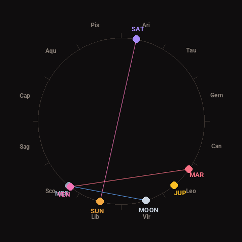
Moon: Waning Crescent (7% illuminated), in Virgo.
Notable planetary angles: Mercury conjunct Venus (1°), Venus square Mars (92°), Moon sextile Mercury (56°), Sun opposite Saturn (176°).
Concurrent space weather: planetary Kp index 1.0; strongest recent solar flare: nothing notable.
This is a factual snapshot, not a claim of cause and effect – researchers are divided on whether lunar, planetary or solar factors influence seismic or weather activity. It’s included so readers can track the pattern for themselves over time.