The National Weather Service has issued a Flood Warning covering 15 areas, issued at 3:47 PM EDT on October 7 by the NWS office in Tampa Bay/Ruskin, Florida. The affected counties include Citrus, Levy, Marion, Lake, Volusia, Baker, and Nassau in Florida; Charlton in Georgia; and Clinton and Scott in Iowa, along with five additional areas.
A Flood Warning means flooding is already happening or is expected to happen soon — this is more serious than a Flood Watch, which only means conditions are favorable. The warning reflects a combination of recent heavy rainfall and rising water levels on rivers, creeks, and low-lying roads across these regions.
What you might notice
Residents in the warned counties may see water covering roads (especially low-water crossings and underpasses), swollen streams and ditches, standing water in yards and fields, and slower or rerouted traffic. In north Florida and southeast Georgia, rivers along the St. Marys and Suwannee basins often rise quickly after heavy rain. In eastern Iowa, the Mississippi River corridor and its tributaries near Clinton and Scott counties can see elevated levels and localized road closures.
Practical steps
First, never drive through floodwater — six inches of moving water can knock an adult down, and a foot can float most vehicles. Turn around and find another route. Second, if you live near a creek, river, or low-lying area, move valuables and vehicles to higher ground and keep a go-bag ready in case water rises overnight. Third, monitor local NWS updates and county emergency management alerts, since warnings can be extended or upgraded as conditions change.
This information comes from the National Weather Service (NWS) Tampa Bay/Ruskin office and official NOAA flood monitoring data.
Frequently Asked Questions
What's the difference between a Flood Watch and a Flood Warning?
A Flood Watch means flooding is possible; a Flood Warning — which is what has been issued here — means flooding is occurring or imminent in the listed counties. If you're in one of the 15 affected areas, take it seriously now.
Is it safe to drive if the road only looks a little flooded?
No — it's the leading cause of flood deaths. Water depth and road damage underneath are impossible to judge, so turn around and take a different route, even for familiar roads.
How long will this Flood Warning last?
Duration varies by county; river flooding can persist for days after rain stops, while flash flooding typically resolves in hours. Check your local NWS office for expiration times specific to your county.
Do I need to evacuate?
Most flood warnings do not require evacuation, but if water is approaching your home or local officials issue an evacuation order, leave promptly for higher ground. Follow guidance from your county emergency management office.
Keep tracking this:
Source: National Weather Service (NWS)
Related Reading
- Emergency Communication: Staying Connected When Towers Go Down
- Earthquake Survival: Precautions, Kit & Early Warning in 2026
- Essential Guide to Preparing for a Nuclear War
Sky & Solar Conditions at the Time
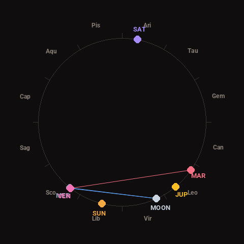
Moon: Waning Crescent (11% illuminated), in Virgo.
Notable planetary angles: Mercury conjunct Venus (1°), Moon sextile Venus (62°), Venus square Mars (93°), Moon sextile Mercury (63°).
Concurrent space weather: planetary Kp index 2.3; strongest recent solar flare: nothing notable.
This is a factual snapshot, not a claim of cause and effect – researchers are divided on whether lunar, planetary or solar factors influence seismic or weather activity. It’s included so readers can track the pattern for themselves over time.