The National Weather Service office in Norman, Oklahoma has issued a Flood Warning covering 24 counties across southern Oklahoma and northern Texas. The warning was issued Wednesday, October 15 at 8:42 AM CDT and remains in effect through Sunday, October 19 at 9:00 PM CDT.
A Flood Warning means flooding is already occurring or is expected to begin soon – this is a step above a Flood Watch, which only means conditions are favorable for flooding. The affected counties include Wichita, Wilbarger, and Cottle in Texas, and Greer, Jackson, Kiowa, Tillman, Cleveland, McClain, and Pottawatomie in Oklahoma, plus 14 additional areas across the region.
Residents in these counties may notice swollen creeks and rivers, water over low-water crossings and rural roads, standing water in fields and low-lying areas, and slower travel on highways where water collects. With the warning spanning four days, waterways are expected to stay high even after the heaviest rain moves through.
What you can do
Never drive through flooded roads. Just six inches of moving water can knock an adult down, and twelve inches can carry away a small car. ‘Turn around, don’t drown’ applies to every crossing, even ones you know well.
Check on low-lying property and livestock. If you live near a creek or river, move valuables, equipment, and animals to higher ground early rather than waiting for water to rise.
Keep a way to receive warnings. A NOAA weather radio or phone alerts with the sound turned on will notify you if the warning is extended or upgraded in your specific county.
This alert is based on official data from the National Weather Service (NWS) Norman office, part of NOAA.
Frequently Asked Questions
How long will this flood warning last?
The current warning runs through Sunday, October 19 at 9:00 PM CDT, though the NWS may extend, trim, or cancel it earlier depending on how rivers and creeks respond to the rain.
What should I do right now if I live in one of these counties?
Avoid flooded roads and low-water crossings, move anything valuable away from creeks and low ground, and keep weather alerts enabled on your phone in case conditions worsen in your specific area.
Is a Flood Warning the same as a Flash Flood Warning?
No. A Flood Warning means flooding is occurring or expected, often from rising rivers and prolonged rain. A Flash Flood Warning is more urgent and means fast, dangerous flooding is happening now – if one is issued for your county, move to higher ground immediately.
Are Oklahoma City or Wichita Falls affected?
Cleveland and McClain counties are in the Oklahoma City metro's southern suburbs, and Wichita County contains Wichita Falls, Texas – so yes, both areas are within the warned region. Urban flooding of streets and underpasses is possible even away from rivers.
Keep tracking this:
Source: National Weather Service (NWS)
Related Reading
- Emergency Communication: Staying Connected When Towers Go Down
- Earthquake Survival: Precautions, Kit & Early Warning in 2026
- Essential Guide to Preparing for a Nuclear War
Sky & Solar Conditions at the Time
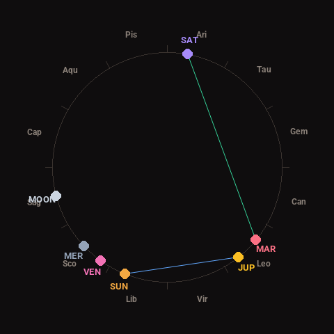
Moon: Waxing Crescent (20% illuminated), in Sagittarius.
Notable planetary angles: Sun sextile Jupiter (60°), Mars trine Saturn (119°).
Concurrent space weather: planetary Kp index 3.0; strongest recent solar flare: nothing notable.
This is a factual snapshot, not a claim of cause and effect – researchers are divided on whether lunar, planetary or solar factors influence seismic or weather activity. It’s included so readers can track the pattern for themselves over time.