The National Weather Service office in Norman, Oklahoma issued a Flash Flood Warning at 10:39 AM CDT on October 15, covering three Texas counties: Foard, Hardeman, and Wilbarger. The warning remains in effect until 1:45 PM CDT.
A Flash Flood Warning means flooding is already happening or is about to happen very soon in the warned area – this is more urgent than a watch, which only means conditions are favorable. The warning covers a rural stretch of North Texas along the Red River, including communities such as Vernon (the Wilbarger County seat), Quanah (Hardeman County), and Crowell (Foard County). Heavy rainfall moving through the region can quickly overwhelm creeks, low-water crossings, and poorly drained roads in this part of the state.
What You Might Notice
Residents in the warned counties may see rapidly rising water on rural roads, swollen creeks and streams, and water pooling in low-lying areas. Low-water crossings – common on county roads in this region – can become impassable within minutes of heavy rain. If you encounter a flooded roadway, do not attempt to drive or walk through it. It takes only about 12 inches of moving water to carry away a small car.
What to Do Right Now
If you live in Foard, Hardeman, or Wilbarger County, avoid travel until the warning expires if possible, and never drive around barricades. Move to higher ground if you are near a creek, arroyo, or low-lying area, and keep a phone handy with wireless emergency alerts enabled. This is a short-fuse warning – it expires at 1:45 PM CDT – but conditions can change quickly, so continue monitoring local radio or weather apps for updates, extensions, or new warnings for downstream areas.
Data for this alert comes from the National Weather Service (NWS) office in Norman, Oklahoma.
Frequently Asked Questions
What should I do right now if I'm in one of these counties?
Avoid driving, especially on rural roads and low-water crossings, and move away from creeks and low-lying areas. If water is rising near your home, move to higher ground immediately.
How long will this warning last?
The warning is in effect until 1:45 PM CDT on October 15, though NWS Norman may extend it or issue new warnings if heavy rain continues.
Is it safe to drive through a flooded road if the water looks shallow?
No – just 12 inches of moving water can sweep away a small vehicle, and the road underneath may be washed out. Turn around and find another route.
Which towns are affected by this warning?
The warning covers Foard, Hardeman, and Wilbarger counties in North Texas, which include communities such as Vernon, Quanah, and Crowell.
Keep tracking this:
Source: National Weather Service (NWS)
Related Reading
- Emergency Communication: Staying Connected When Towers Go Down
- Earthquake Survival: Precautions, Kit & Early Warning in 2026
- Essential Guide to Preparing for a Nuclear War
Sky & Solar Conditions at the Time
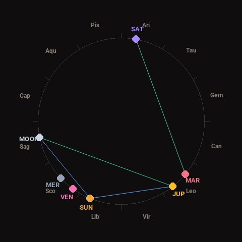
Moon: Waxing Crescent (23% illuminated), in Sagittarius.
Notable planetary angles: Sun sextile Jupiter (60°), Mars trine Saturn (119°), Moon trine Jupiter (117°), Sun sextile Moon (57°).
Concurrent space weather: planetary Kp index 2.7; strongest recent solar flare: nothing notable.
This is a factual snapshot, not a claim of cause and effect – researchers are divided on whether lunar, planetary or solar factors influence seismic or weather activity. It’s included so readers can track the pattern for themselves over time.