The National Weather Service has active Flood Warnings covering 17 areas across four states, with the alert issued Thursday, October 16 at 9:21 PM EDT by the NWS office in Melbourne, Florida. The warnings span a wide swath of the southern United States, including Lake, Volusia, and Sarasota counties in Florida; Brantley County in Georgia; Brewster, Val Verde, Wichita, and Wilbarger counties in Texas; and Payne and Jackson counties in Oklahoma, plus seven additional areas.
A Flood Warning means flooding is already happening or will happen very soon in the warned areas — this is a step above a Flood Watch, which only means conditions are favorable. Residents in these counties may notice water rising over roads, water collecting in low-lying areas and underpasses, swollen creeks and rivers, and in some cases water approaching homes or businesses. Conditions can change quickly overnight, when rising water is harder to see.
Because the warnings stretch across multiple states, the flooding is likely tied to heavy rainfall moving through several regional weather systems rather than a single storm. Drivers should treat any water covering a road as impassable — it takes only about a foot of moving water to sweep away a small car, and floodwater often hides washed-out pavement underneath.
What to watch and do
1. Avoid flooded roads. If you encounter water over a roadway, turn around and find another route. Never drive around barricades. 2. Move to higher ground if water rises near your home. If officials in your county issue an evacuation notice, leave promptly rather than waiting. 3. Stay updated through the night. Keep a weather radio or phone alerts enabled, since flash flooding can develop or worsen after dark. Charge devices in case of power interruptions.
Data for this alert comes from the National Weather Service (NOAA), including the NWS Melbourne, Florida forecast office.
Frequently Asked Questions
What does a Flood Warning mean, exactly?
A Flood Warning means flooding is occurring or imminent in the warned area — it's an upgrade from a Flood Watch, which only means flooding is possible. You should act now, not wait to see what happens.
What should I do right now if I'm in one of these counties?
Avoid driving through any water-covered roads, move away from creeks, rivers, and low-lying areas, and monitor local NWS alerts. If water approaches your home or officials order an evacuation, move to higher ground immediately.
Why are warnings spread across Florida, Georgia, Texas, and Oklahoma?
The 17 warned areas fall under multiple NWS forecast offices handling separate heavy-rain events across the southern U.S. at the same time. The single alert notice aggregates warnings from several regions, not one giant storm.
How long will the flooding last?
Duration varies by location — warnings typically remain in effect until water levels recede below flood stage, which can range from hours to a few days for rivers. Check your local NWS office for the expiration time on your county's specific warning.
Keep tracking this:
Source: National Weather Service (NWS)
Related Reading
- Emergency Communication: Staying Connected When Towers Go Down
- Earthquake Survival: Precautions, Kit & Early Warning in 2026
- Essential Guide to Preparing for a Nuclear War
Sky & Solar Conditions at the Time
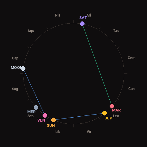
Moon: First Quarter (35% illuminated), in Capricorn.
Notable planetary angles: Mars trine Saturn (120°), Moon sextile Venus (61°), Sun sextile Jupiter (61°).
Concurrent space weather: planetary Kp index 2.3; strongest recent solar flare: nothing notable.
This is a factual snapshot, not a claim of cause and effect – researchers are divided on whether lunar, planetary or solar factors influence seismic or weather activity. It’s included so readers can track the pattern for themselves over time.