The National Weather Service office in Tiyan, Guam has issued a Tropical Storm Warning for the islands of Tinian and Saipan in the Northern Mariana Islands. The warning was issued at 9:13 AM Chamorro Standard Time (ChST) on October 17. A Tropical Storm Warning means tropical storm conditions — sustained winds of 39 to 73 mph, often with heavy rain — are expected in the warned area within 36 hours.
Residents of Saipan and Tinian can expect strengthening winds, periods of heavy rainfall, rough surf, and hazardous seas around the islands. Power outages are possible as winds increase, and flooding can occur in low-lying and poorly drained areas. Small craft should remain in port, and inter-island travel by boat or small aircraft is likely to be disrupted until conditions improve.
This warning covers the two main populated islands of the Northern Mariana Islands. Saipan is the most populated island in the commonwealth, so a significant number of residents fall under this alert. Guam itself is not included in this warning as of the latest issuance, but nearby islands should continue monitoring forecasts since tropical systems can shift.
What to do now
Secure loose outdoor items such as furniture, tools, and trash cans that could become airborne in strong winds. Charge phones and battery banks, fill water containers, and make sure flashlights and a battery-powered radio are working in case power goes out. Stay indoors and away from windows once conditions deteriorate, and avoid driving through flooded roads — even shallow moving water can stall or sweep away a vehicle.
Continue monitoring local broadcasts and official updates for any changes to the storm’s track or intensity, including possible upgrades to typhoon status if the system strengthens.
Data for this alert comes from the National Weather Service office in Tiyan, Guam (NOAA/NWS).
Frequently Asked Questions
What does a Tropical Storm Warning actually mean?
It means tropical storm conditions — sustained winds of 39 to 73 mph with heavy rain — are expected in the warned area within 36 hours. For Tinian and Saipan, this warning was issued at 9:13 AM ChST on October 17, so conditions could deteriorate later today or into tonight.
What should I do right now?
Secure or bring in anything loose outdoors, charge your devices, and stock up on water and essentials before winds pick up. Once conditions worsen, stay indoors away from windows and avoid driving through flooded areas.
Could this storm get stronger than a tropical storm?
Tropical systems in this region can intensify into typhoons, so it is worth monitoring NWS Tiyan updates closely. If the system strengthens, the warning could be upgraded to a Typhoon Warning for Saipan and Tinian.
Is Guam affected by this warning?
No — as of the latest issuance, the warning covers only Tinian and Saipan. However, tropical systems can shift, so residents of Guam and nearby islands should keep an eye on updated forecasts from NWS Tiyan.
Keep tracking this:
Source: National Weather Service (NWS)
Related Reading
- Emergency Communication: Staying Connected When Towers Go Down
- Earthquake Survival: Precautions, Kit & Early Warning in 2026
- Essential Guide to Preparing for a Nuclear War
Sky & Solar Conditions at the Time
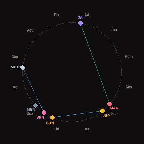
Moon: First Quarter (34% illuminated), in Capricorn.
Notable planetary angles: Mars trine Saturn (120°), Moon sextile Venus (61°), Sun sextile Jupiter (61°).
Concurrent space weather: planetary Kp index 2.3; strongest recent solar flare: nothing notable.
This is a factual snapshot, not a claim of cause and effect – researchers are divided on whether lunar, planetary or solar factors influence seismic or weather activity. It’s included so readers can track the pattern for themselves over time.