The A66, a major trans-Pennine route linking Cumbria with the A1(M) in the North East of England, is closed in both directions following a multi-vehicle crash. Emergency services are on scene, and traffic delays are building on both approaches as vehicles are held or diverted.
Drivers in the area should expect significant hold-ups. Diversions are being put in place, but alternative routes through the Pennines are narrow, slower, and quickly become congested when the A66 closes. If you are already approaching the closure, follow police and National Highways signage rather than your sat nav, which may route you onto unsuitable rural roads.
Who is affected: Anyone travelling between Cumbria and County Durham/North Yorkshire today, including freight traffic — the A66 is a key east-west HGV corridor. Local communities along diversion routes will see heavier-than-normal traffic. Air ambulance and recovery operations at the scene mean the closure could last several hours, and full collision investigation work can extend closures further.
What to do
Reconsider your journey. If you haven’t set off, delay travel or use the M62 corridor further south as an alternative cross-Pennine route, though it will be busier than usual.
If you’re stuck in the queue: stay in your vehicle unless directed otherwise, keep your engine use moderate to conserve fuel, and keep warm clothing and water accessible — standard advice on this exposed upland route, especially in poor weather.
Check before you travel later today. National Highways provides live updates on closures, estimated reopening times, and diversion routes via its traffic information service and social feeds.
This report is based on live traffic and incident data from National Highways, which manages England’s motorway and major A-road network.
Frequently Asked Questions
How long will the A66 stay closed?
Multi-vehicle crashes typically require several hours for casualty care, vehicle recovery, and scene investigation. National Highways usually publishes an estimated reopening time once the scene is assessed — check its live traffic service for updates.
What's the best alternative route?
The signed diversion is the safest option to follow. For longer cross-Pennine journeys, the M62 to the south is the main alternative, though expect it to be busier than normal while the A66 is shut.
I'm stuck in the queue — what should I do?
Remain in your vehicle with your seatbelt available unless emergency services direct you to leave. Conserve fuel, keep warm, and avoid walking on the carriageway.
Is the closure weather-related?
The closure is due to a multi-vehicle crash rather than weather itself. However, the A66 is a high, exposed route where wind, ice, and rain can contribute to collisions and slow recovery work, so conditions on diversion routes may also be poor.
Keep tracking this:
Source: News & Star
Related Reading
Sky & Solar Conditions at the Time
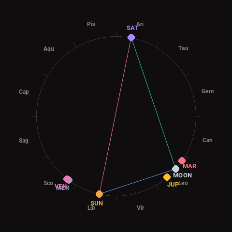
Moon: Waning Crescent (25% illuminated), in Leo.
Notable planetary angles: Sun sextile Moon (60°), Moon trine Saturn (121°), Sun opposite Saturn (179°), Mercury conjunct Venus (2°).
Concurrent space weather: planetary Kp index 3.7; strongest recent solar flare: M1.1-class.
This is a factual snapshot, not a claim of cause and effect – researchers are divided on whether lunar, planetary or solar factors influence seismic or weather activity. It’s included so readers can track the pattern for themselves over time.