
Last updated November 2, 2026 at 13:00 UTC. This page is updated in place as the situation changes, rather than published as a new article each time.
The National Weather Service in Melbourne, Florida has issued a Flash Flood Warning for Brevard County, effective this morning, November 2, from 7:56 AM EST until 9:45 AM EST. Flash flood warnings are issued when flooding is already occurring or expected to begin very soon, and they call for immediate caution — especially on roads and in low-lying areas.
Residents across Brevard County — including communities along the Space Coast such as Melbourne, Palm Bay, Titusville, and Cocoa — may notice rapidly rising water on streets, swollen ditches and drainage canals, and slow-moving or stalled traffic during the morning commute. Even a few inches of moving water can sweep away a vehicle, and standing water often hides washed-out pavement beneath it.
What to do right now
If you are in Brevard County this morning, avoid driving through flooded roads — turn around and find another route. Move to higher ground if water is rising near your home, and never walk through floodwater, which can carry debris, contamination, and hidden currents. Keep children and pets away from ditches, culverts, and retention ponds, which fill dangerously fast during heavy rain.
The warning is currently set to expire at 9:45 AM EST, though it could be extended, upgraded, or allowed to expire early depending on conditions. Continue monitoring local weather radio, county emergency alerts, or trusted local news for updates, and avoid unnecessary travel until the heaviest rain has passed and road conditions improve.
This information comes from the National Weather Service (NWS) office in Melbourne, Florida.
Frequently Asked Questions
What should I do right now if I'm in Brevard County?
Stay off flooded roads and avoid unnecessary travel until the warning expires at 9:45 AM EST. If water is rising near your home, move to higher ground immediately and never walk or drive through floodwater.
How long will this flooding last?
The Flash Flood Warning is in effect until 9:45 AM EST on November 2, though NWS Melbourne may extend or cancel it early depending on rainfall. Street flooding can linger after the rain stops, so continue to use caution through the morning.
Is it safe to drive to work this morning?
Only if your route is clear of standing water — never drive through a flooded roadway, as the depth and road condition underneath are impossible to judge. If you encounter water covering the road, turn around and take an alternate route.
Could this warning be upgraded or extended?
Yes. If heavy rain continues or flooding worsens, NWS Melbourne can extend the warning beyond 9:45 AM EST or issue additional alerts. Keep weather alerts enabled on your phone or monitor NOAA Weather Radio for the latest updates.
Update History
Earlier updates on this page, newest first:
- Nov 1, 2026 – Flash Flood Emergency: Pearl River, MS (National Weather Service (NWS))
- Sep 26, 2026 – Flash Flood Emergency Declared for Socorro, New Mexico
- Sep 24, 2026 – Flash Flood Emergency: Lincoln, New Mexico — Warning Until 7:30 PM MDT
- Sep 22, 2026 – Flash Flood Emergency: Mora, New Mexico — Warning Until 4:30 PM MDT
- Sep 2, 2026 – Flash Flood Emergency: Hardin and Tyler County, Texas — Morning of September 2
- Aug 16, 2026 – Flash Flood Emergency Declared in Hawaii—What You Need to Know
- Aug 11, 2026 – Flash Flood Emergency Declared in Perry, Ohio
- Aug 2, 2026 – Flash Flood Emergency Declared in Surry, North Carolina
- Jul 30, 2026 – Flash Flood Emergency Declared in Ouray, Colorado
- Jul 21, 2026 – Flash Flood Emergency Issued for Three West Virginia Counties
- Jul 19, 2026 – Flash Flood Emergency Declared for Beaver, Utah Through Evening
- Jul 17, 2026 – Flash Flood Emergency: Crockett, TX
- Jul 16, 2026 – Flash Flood Emergency Declared in Blanco, Texas Through Evening
- Jul 15, 2026 – Flash Flood Emergency Declared in Kendall, Texas
- Jul 10, 2026 – Flash Flood Emergency Declared in Missouri; Immediate Action Needed
Keep tracking this:
Source: National Weather Service (NWS)
Related Reading
- Emergency Communication: Staying Connected When Towers Go Down
- Earthquake Survival: Precautions, Kit & Early Warning in 2026
- Essential Guide to Preparing for a Nuclear War
Sky & Solar Conditions at the Time
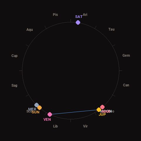
Moon: Last Quarter (42% illuminated), in Leo.
Notable planetary angles: Moon conjunct Mars (0°), Venus sextile Jupiter (61°).
Concurrent space weather: planetary Kp index 2.3; strongest recent solar flare: nothing notable.
This is a factual snapshot, not a claim of cause and effect – researchers are divided on whether lunar, planetary or solar factors influence seismic or weather activity. It’s included so readers can track the pattern for themselves over time.