Highway 3, the Crowsnest route through southern British Columbia, is closed in both directions west of Manning Park. The closure blocks a key east-west corridor through the Cascade Mountains, affecting travel between the Lower Mainland and the Interior and Kootenay regions.
Full closures of this size are typically caused by severe weather such as flooding, ice, or wildfire, a structural problem with the road, or a serious multi-vehicle incident. Because this is a mountain pass highway with limited detour options, drivers should expect significant delays and should not assume the route will reopen quickly.
Who is affected: Anyone traveling between Hope and Princeton and points beyond, including commercial trucks that rely on Highway 3 as an alternative to the Coquihalla (Highway 5). Local traffic near Sunshine Valley and the Manning Park area may also face restrictions or congestion as vehicles are turned around.
What to watch and how to prepare
Check before you go. Road conditions in mountain passes can change fast. Check DriveBC for the official reopening status and the stated cause before leaving, and check weather conditions for the pass if you plan to travel later today.
Have an alternate plan. Depending on your destination, Highway 1 (Fraser Canyon) or Highway 5 (Coquihalla) may serve as detours, but both add substantial time. Confirm those routes are open as well before committing.
Carry a winter/emergency kit. If you are already on the road near the closure, keep fuel above half a tank and have water, snacks, warm clothing, and a phone charger. Being turned around or held in a queue in a mountain corridor is a common, manageable situation if you are prepared.
Information on this closure is drawn from provincial road condition reporting via DriveBC, with regional weather context from Environment and Climate Change Canada.
Frequently Asked Questions
Is there a detour around the Highway 3 closure?
There is no simple local detour west of Manning Park, so most through traffic would need to reroute via Highway 1 (Fraser Canyon) or Highway 5 (Coquihalla), which adds significant travel time. Check DriveBC to confirm those routes are open before departing.
Why is Highway 3 closed, and how long will it last?
The specific cause has not been confirmed in initial reports; closures of this scale are usually due to severe weather, a structural issue, or a serious crash. Reopening times depend on the cause, so monitor DriveBC for official updates rather than relying on estimates.
I'm already traveling toward Manning Park – what should I do?
Expect to be stopped or turned around; follow directions from flagging crews and police, and do not attempt to bypass barricades. Keep fuel topped up and have warm clothing, water, and snacks in case you are held in a queue.
Will this closure affect deliveries or truck traffic?
Yes, Highway 3 is a major freight route, so commercial traffic will be diverted to the Coquihalla or Fraser Canyon corridors. Some deliveries between the coast and the southern Interior may be delayed until the highway reopens.
Keep tracking this:
Source: Castanet
Related Reading
Sky & Solar Conditions at the Time
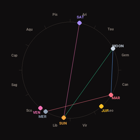
Moon: Waning Gibbous (78% illuminated), in Gemini.
Notable planetary angles: Mercury square Mars (89°), Moon sextile Mars (58°), Sun trine Moon (124°), Sun opposite Saturn (176°).
Concurrent space weather: planetary Kp index 0.7; strongest recent solar flare: nothing notable.
This is a factual snapshot, not a claim of cause and effect – researchers are divided on whether lunar, planetary or solar factors influence seismic or weather activity. It’s included so readers can track the pattern for themselves over time.