

On March 26, 2026, GPS jamming knocked out navigation systems on more than 1,100 ships in the Middle East Gulf in a single day, with vessels suddenly reporting their position as an airport, a nuclear plant, or dry land they were nowhere near. It was not an isolated glitch. Reported GPS jamming events rose 67 percent in 2025 compared with 2023, while spoofing incidents climbed 193 percent over the same period, and the disruption now reaches aircraft flying hundreds of nautical miles outside any active conflict zone. Satellites made navigation nearly invisible for most of a generation. What 2026 has made clear is that the system underneath that convenience is more fragile than it looks, and the older methods it replaced never actually stopped working.
The Sun Was the First Compass
The simplest and most reliable natural navigation method uses nothing but a straight stick and patience. Plant a stick vertically in open ground, sighted against the sky to make sure it stands truly upright, and mark the tip of its shadow with a stone. That first shadow mark always falls to the west, everywhere on earth, because the sun’s apparent path moves from east to west regardless of hemisphere. Wait ten to fifteen minutes for the shadow tip to shift a few centimetres, mark the new position, and draw a line connecting the two points to get an approximate east-west line; standing with the first mark on your left and the second on your right leaves you facing north. With a full thirty-minute wait and careful technique, this shadow-stick method can deliver accuracy within about five degrees, though rushing it can let the error drift toward fifteen.
An analog watch works on a related principle, though it demands more caution than most guides admit. Pointing the hour hand at the sun and bisecting the angle between the hour hand and 12 o’clock gives an approximate north-south line in the northern hemisphere, but the method is sensitive to the time of year, daylight saving adjustments, and how close you are to solar noon, which is why it should be treated as a rough cross-check rather than a primary method.
None of these sun-based techniques require any equipment beyond what most people are already carrying. That is precisely why they survived as folk knowledge for so long before satellites made them feel obsolete.
Reading the Night Sky
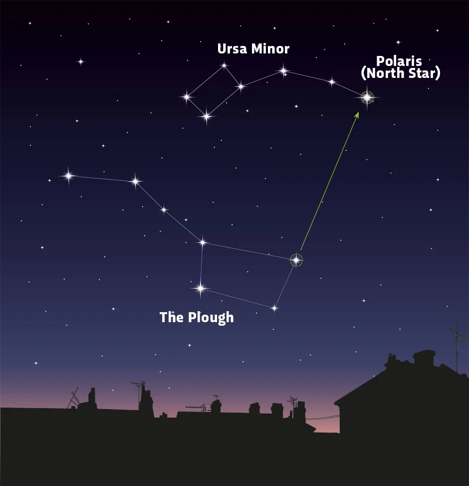
Where the sun fails, the stars pick up the work, and the northern sky offers a shortcut most people already half-remember from childhood. Locate the Big Dipper, then extend an imaginary line from the two stars forming the outer edge of its bowl outward until it reaches the next bright star in that direction: that star is Polaris, sitting almost directly above the North Pole and staying essentially fixed while every other star appears to rotate around it through the night. Because Polaris barely moves, it remains one of the most dependable fixed references available after dark, with no equipment and no calculation required beyond finding one familiar constellation.
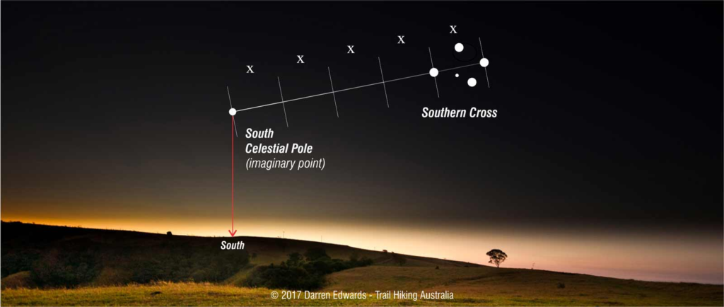
The southern hemisphere has no equivalent pole star, which forced a different solution built around the Southern Cross. Extending a line from the foot of the Southern Cross along its long axis, roughly four and a half times the constellation’s own length, points to the south celestial pole, and dropping a line straight down from that point to the horizon marks true south.
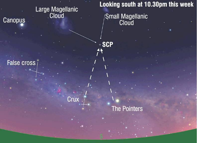
A second check comes from the two bright stars known as the Pointers: a line drawn between them, bisected at a right angle, crosses the Southern Cross’s extended axis at very close to the same spot, giving two independent lines of evidence that converge on the same answer, which is itself the core discipline of any competent navigation or intelligence work.
Long before either of these tricks were written down in a survival manual, Polynesian navigators had already built an entire open-ocean navigation system around exactly this kind of star tracking. Master wayfinders memorised the rising and setting points of hundreds of stars, organising them into what became known as a star compass, and used that memory alongside wave patterns and bird flight to cross thousands of kilometres of open Pacific Ocean with no instruments at all. Much of that knowledge nearly disappeared after contact with the West, and it took the 1976 voyage of the canoe Hōkūleʻa from Hawaii to Tahiti using only traditional wayfinding to prove, for the first time in roughly 800 years, that the old system still worked exactly as well as it always had.
The Myths Worth Discarding
Not every piece of navigation folklore survives scrutiny, and the most persistent one deserves to be retired outright. The idea that moss grows only on the north side of trees is repeated so often that it functions as a kind of default backup plan for people without a compass, but moss growth is driven by moisture and shade, not by geomagnetic orientation. Rainwater flowing down a tree’s bark creates localised wet channels called stemflow paths, and those paths can establish moss on any face of a trunk depending on the specific tree, canopy cover, and terrain, not just the shaded northern side. In an open field in the northern hemisphere the north side is indeed reliably shadier, which is exactly why the myth persists, but the same trick fails constantly in dense forest, where shade comes from neighbouring trees rather than the sun’s arc. A method that works some of the time and fails the rest of the time is more dangerous than no method at all, because it produces false confidence exactly when confidence is least warranted.
Beyond a Single Bearing: Dead Reckoning and Terrain
Finding one accurate direction is only the starting point. Getting somewhere specific requires holding that bearing over distance and time, a discipline sailors and pilots call dead reckoning: starting from a known position, tracking heading and rough speed, and continuously updating an estimated location as terrain and time pass, rather than re-establishing direction from scratch at every step.
Pairing a shadow-stick bearing or a Polaris sighting with visible terrain features, a distant ridgeline, a river’s course, a consistent wind direction, turns a single momentary reading into a navigable line of travel rather than a fact that decays the moment you look away from the sky. This is also where natural navigation and modern open-source analysis share more in common than people expect: both disciplines treat any single indicator as provisional until a second, independently derived one confirms it, and both fail in the same way when someone trusts one signal too far past the point where it was actually reliable.
The Broader Lesson
The broader lesson sits underneath all of these techniques rather than inside any single one of them. No natural navigation method should be trusted alone, whether it is a shadow stick, a star, or a patch of moss. Serious practitioners cross-check two or three independent indicators before committing to a direction, the same convergence principle that separates a confirmed intelligence finding from an educated guess. A compass can fail, a battery can die, and now, evidently, an entire satellite constellation can be jammed by an adversary with no direct stake in your particular journey. The methods that predate GPS by centuries never actually stopped being accurate. The only real question is how many people would still recognise the sky well enough to use them if the signal went out tonight.