The National Weather Service office in Grand Junction, Colorado has issued a Flash Flood Warning for San Juan County, Utah. The warning was issued at 9:58 AM MDT on September 15 and remains in effect until 1:00 PM MDT.
A flash flood warning is the most urgent type of flood alert — it means flash flooding is already occurring or is about to begin, not just that conditions favor it. In southeast Utah’s canyon country, heavy rain from slow-moving thunderstorms can send water surging through normally dry washes, slot canyons, and low-lying roads within minutes, even in areas where it isn’t actively raining.
What readers in the area might notice
Residents and travelers in San Juan County — including areas around Blanding, Monticello, Bluff, and popular backcountry destinations — may see rapid rises in creeks and washes, muddy or debris-filled runoff crossing roadways, and water pooling in low spots. If you are hiking in a canyon, watch for suddenly rising or muddy water and a rumbling sound upstream; both are signs to move to higher ground immediately.
Who is affected
Anyone in or traveling through the warned portion of San Juan County is at risk, particularly drivers on rural highways and unpaved roads, hikers and campers in canyon terrain, and residents near washes and small streams. Visitors unfamiliar with desert flash flooding should take this warning especially seriously — dry-looking ground can become a fast-moving channel with little warning.
What to do right now
First, never drive or walk through floodwater — even six inches of moving water can knock a person down, and a foot can carry away a vehicle. Turn around, don’t drown. Second, if you’re in a canyon or near a wash, move to higher ground now and stay there until the warning expires at 1:00 PM. Third, keep a phone or weather radio handy for updated alerts, since additional thunderstorms could extend or expand the warning this afternoon.
This alert is based on official warning data issued by the National Weather Service (NWS) office in Grand Junction, Colorado.
Frequently Asked Questions
What should I do right now if I'm in San Juan County?
Move away from washes, creeks, and low-water crossings, and get to higher ground if you're in canyon terrain. Do not attempt to drive through any water covering a roadway — turn around and find another route.
How long will this warning last?
The current warning is in effect until 1:00 PM MDT on September 15, but the NWS may extend it or issue new warnings if thunderstorms continue producing heavy rain.
Is it dangerous even if it isn't raining where I am?
Yes. Flash floods in Utah's canyon country are often caused by rain falling miles upstream, so a wall of water can arrive under sunny skies. That's why the warning covers the whole area, not just where storms are visible.
I'm hiking or camping in the backcountry — should I leave?
If you're in a slot canyon, wash, or other low-lying terrain, move to higher ground immediately rather than trying to hike out through flood-prone areas. Wait until the warning expires and water levels have visibly receded before continuing.
Keep tracking this:
Source: National Weather Service (NWS)
Related Reading
- Emergency Communication: Staying Connected When Towers Go Down
- Earthquake Survival: Precautions, Kit & Early Warning in 2026
- Essential Guide to Preparing for a Nuclear War
Sky & Solar Conditions at the Time
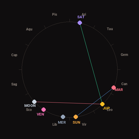
Moon: Waxing Crescent (21% illuminated), in Scorpio.
Notable planetary angles: Sun sextile Mars (60°), Moon square Jupiter (91°), Jupiter trine Saturn (124°).
Concurrent space weather: planetary Kp index 2.3; strongest recent solar flare: nothing notable.
This is a factual snapshot, not a claim of cause and effect – researchers are divided on whether lunar, planetary or solar factors influence seismic or weather activity. It’s included so readers can track the pattern for themselves over time.