The National Weather Service office in Tiyan, Guam, issued a Tropical Storm Warning early Wednesday morning at 2:57 AM ChST (Chamorro Standard Time) for the islands of Saipan and Tinian in the Northern Mariana Islands. The warning covers four areas in total: the islands of Saipan and Tinian themselves, plus the coastal waters surrounding both islands.
A Tropical Storm Warning means that tropical storm conditions – sustained winds of 39 to 73 mph, heavy rain, and rough seas – are expected within the warning area, generally within 36 hours. This is the higher tier of alert: preparations should already be underway or completed, not just planned.
What residents and mariners can expect
People on Saipan and Tinian should expect strengthening winds, periods of heavy rainfall, and deteriorating sea conditions. Coastal waters around both islands are covered by the warning, so small craft and commercial vessels should remain in port. Loose outdoor items such as patio furniture, tarps, and signage can become airborne hazards as winds pick up. Power interruptions are possible if winds bring down lines or vegetation onto utility infrastructure, and localized flooding can develop quickly in low-lying areas during intense downpours.
Anyone scheduled to travel to or from Saipan International Airport or Tinian’s airport should check with their airline, as flights are frequently delayed or cancelled when tropical storm conditions approach the islands.
Sensible steps right now
First, secure or bring inside anything loose outdoors, and make sure you have flashlights, charged phones, and a battery or power bank ready in case the electricity goes out. Second, avoid the water entirely – the coastal water warnings mean dangerous surf, rip currents, and rapidly shifting seas, even for experienced boaters. Third, keep at least a day or two of drinking water and non-perishable food accessible, and monitor local radio or official updates since warnings for the Marianas can be upgraded to typhoon strength if a storm intensifies faster than forecast.
This alert is based on the official Tropical Storm Warning issued by the National Weather Service (NWS) office in Tiyan, Guam, part of NOAA.
Frequently Asked Questions
What does a Tropical Storm Warning actually mean for me?
It means winds of 39-73 mph with heavy rain are expected within about 36 hours for Saipan, Tinian, and their surrounding coastal waters – you should finish preparations now rather than wait.
Is it safe to stay home, or should I evacuate?
For a tropical storm (below typhoon strength), most residents in well-built concrete structures can shelter in place, but those in light wood or tin structures should consider moving to a designated public shelter – follow Commonwealth of the Northern Mariana Islands emergency management guidance.
How long will this last?
Tropical storm conditions typically affect a single island for 12 to 24 hours as the system passes, though lingering rain and rough seas can continue afterward; monitor NWS Tiyan updates for when the warning is downgraded.
Can I still fly out or take a boat between islands?
Expect flight delays and cancellations at Saipan and Tinian airports once winds rise, and all boating should be suspended – the warning explicitly covers the coastal waters of both islands, meaning seas are dangerous.
Keep tracking this:
Source: National Weather Service (NWS)
Related Reading
- Emergency Communication: Staying Connected When Towers Go Down
- Earthquake Survival: Precautions, Kit & Early Warning in 2026
- Essential Guide to Preparing for a Nuclear War
Sky & Solar Conditions at the Time
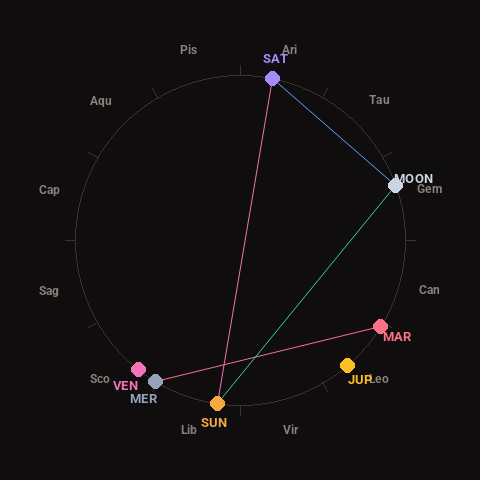
Moon: Waning Gibbous (73% illuminated), in Gemini.
Notable planetary angles: Moon sextile Saturn (59°), Mercury square Mars (89°), Sun trine Moon (117°), Sun opposite Saturn (177°).
Concurrent space weather: planetary Kp index 1.0; strongest recent solar flare: nothing notable.
This is a factual snapshot, not a claim of cause and effect – researchers are divided on whether lunar, planetary or solar factors influence seismic or weather activity. It’s included so readers can track the pattern for themselves over time.