The National Weather Service office in Dodge City has issued a Flash Flood Warning for the Ford, Kansas area. The warning was issued at 2:32 PM CDT on October 1 and remains in effect until 5:30 PM CDT. This means flash flooding is either occurring now or expected to begin shortly — this is not just a possibility, it is an active warning requiring attention.
Residents in and around Ford can expect rapidly rising water on roads, in low-lying areas, and along small creeks and drainage channels. Heavy rainfall over a short period can overwhelm ditches and storm drains quickly, and rural roads in this part of southwest Kansas can become impassable in minutes. Low-water crossings, which are common in the region, are especially dangerous during events like this.
Anyone in the warned area should avoid driving through water-covered roads. It takes only about six inches of fast-moving water to knock a person down, and twelve inches can carry away a small car. The rule of thumb is simple: turn around, don’t drown. If you live near a creek, dry wash, or low-lying area, be ready to move to higher ground quickly.
What to Watch Over the Next Few Hours
First, monitor local conditions through at least two sources — a NOAA weather radio, local TV or radio, or wireless emergency alerts on your phone — since conditions can change faster than forecast updates. Second, keep an eye on small streams and drainage areas near your home or route home; water levels in flash flood events can rise within minutes. Third, if you must travel before 5:30 PM, check road conditions before leaving and have an alternate route that avoids low-water crossings.
The warning is currently set to expire at 5:30 PM CDT, but it could be extended or reissued if heavy rain continues or runoff keeps water levels high. Even after the rain stops, floodwaters can remain dangerous for hours.
This alert is based on data from the National Weather Service (NWS) office in Dodge City, Kansas.
Frequently Asked Questions
What should I do right now if I'm in the Ford, KS area?
Stay off flooded roads and avoid low-water crossings entirely. Move to higher ground if you are near a creek, ditch, or low-lying area, and keep monitoring NWS updates until the warning expires at 5:30 PM CDT.
How long will this flash flood threat last?
The current warning runs until 5:30 PM CDT on October 1. It may be extended if heavy rain continues, and standing water can remain hazardous even after the warning ends.
Is it safe to drive through the water if it looks shallow?
No. You cannot judge water depth or road condition underneath by looking at it — just 12 inches of moving water can sweep away a car. Turn around and find another route.
Where can I get updates on this warning?
Follow the National Weather Service office in Dodge City through NOAA weather radio, local news, or wireless emergency alerts on your phone for the latest information.
Keep tracking this:
Source: National Weather Service (NWS)
Related Reading
- Emergency Communication: Staying Connected When Towers Go Down
- Earthquake Survival: Precautions, Kit & Early Warning in 2026
- Essential Guide to Preparing for a Nuclear War
Sky & Solar Conditions at the Time
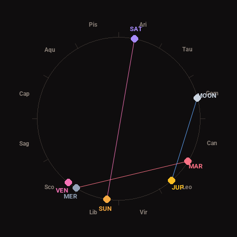
Moon: Waning Gibbous (69% illuminated), in Gemini.
Notable planetary angles: Mercury square Mars (90°), Sun opposite Saturn (177°), Moon sextile Jupiter (64°).
Concurrent space weather: planetary Kp index 1.3; strongest recent solar flare: nothing notable.
This is a factual snapshot, not a claim of cause and effect – researchers are divided on whether lunar, planetary or solar factors influence seismic or weather activity. It’s included so readers can track the pattern for themselves over time.