The National Weather Service office in Kansas City/Pleasant Hill, Missouri, issued a Flood Warning on October 1 at 3:50 PM CDT covering 103 areas across Missouri and Kansas. This is one of the broader flood alerts the region has seen recently, spanning communities on both sides of the state line.
A Flood Warning means flooding is already occurring or is imminent in the warned areas – it is a step above a Flood Watch, which only means conditions are favorable for flooding. If you are in one of the covered counties, treat this as an active situation, not a possibility.
Among the named areas are Carroll, Chariton, Saline, Lafayette, Platte, Jackson, Buchanan, and Andrew counties in Missouri, along with Leavenworth and Doniphan counties in Kansas, plus 93 additional areas. This includes the greater Kansas City metro region (Jackson and Platte counties) as well as many rural communities along the Missouri River corridor.
What You Might Notice
Residents in affected areas may see water covering roads, especially low-water crossings and underpasses; rising creeks, streams, and rivers; and standing water in fields and low-lying neighborhoods. Rural roads are often the first to become impassable. The Missouri River and its tributaries may run high and fast, and drainage systems in urban areas can be overwhelmed during heavy rain, causing street flooding even away from rivers.
What To Do
First, never drive through water covering a road – as little as 12 inches of moving water can carry away a small car, and the road underneath may be washed out. Turn around, don’t drown. Second, if you live near a creek, river, or low-lying area, be ready to move to higher ground quickly and keep a charged phone and flashlight handy. Third, check on neighbors who may need help, and monitor local radio or weather alerts for updates, since flood warnings can be extended or upgraded as conditions change.
Data for this alert comes from the National Weather Service (NWS) Kansas City/Pleasant Hill office, part of NOAA.
Frequently Asked Questions
What should I do right now if I'm in one of the warned areas?
Avoid driving, especially at night when flooded roads are hard to see, and never cross water-covered roadways. If you live near a stream, river, or low spot, be prepared to move to higher ground.
Is the Kansas City metro area affected?
Yes – Jackson and Platte counties in Missouri, which include much of the Kansas City metro, are among the named areas, along with Leavenworth County, Kansas.
How long will this flood warning last?
The warning was issued at 3:50 PM CDT on October 1, and flood warnings typically remain in effect until water recedes below flood stage. Check NWS updates for the specific expiration time in your county.
What's the difference between a Flood Watch and a Flood Warning?
A watch means flooding is possible; a warning means flooding is happening or about to happen. This is a warning, so take it seriously and avoid flooded areas.
Keep tracking this:
Source: National Weather Service (NWS)
Related Reading
- Emergency Communication: Staying Connected When Towers Go Down
- Earthquake Survival: Precautions, Kit & Early Warning in 2026
- Essential Guide to Preparing for a Nuclear War
Sky & Solar Conditions at the Time
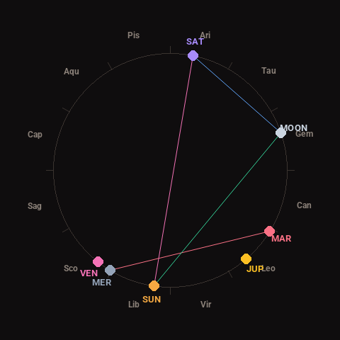
Moon: Waning Gibbous (72% illuminated), in Gemini.
Notable planetary angles: Moon sextile Saturn (60°), Mercury square Mars (89°), Sun opposite Saturn (177°), Sun trine Moon (117°).
Concurrent space weather: planetary Kp index 1.3; strongest recent solar flare: nothing notable.
This is a factual snapshot, not a claim of cause and effect – researchers are divided on whether lunar, planetary or solar factors influence seismic or weather activity. It’s included so readers can track the pattern for themselves over time.