The National Weather Service office in Charleston, West Virginia, issued a Flash Flood Warning early Saturday morning, September 20, at 1:42 AM EDT. The warning remains in effect until 7:45 AM EDT and currently covers 17 areas across parts of Ohio, West Virginia, and Iowa.
Confirmed areas in the warning include Athens, Meigs, Washington, and Vinton counties in Ohio; Jackson, Mason, and Wood counties in West Virginia; and Cedar, Iowa, and Johnson counties in Iowa, with seven additional areas also covered. A Flash Flood Warning means flooding is already occurring or is about to happen – this is more urgent than a watch, which only means conditions are favorable.
What you might notice
Residents in the warned areas may see rapidly rising water on roads, in low-lying spots, and along creeks and small streams. Water can cover roads quickly at night, making hazards hard to see. Poor drainage areas, underpasses, and basements are especially vulnerable. Because this warning came in the overnight hours, many people may be asleep while conditions develop.
What to do
First, never drive or walk through floodwater – just six inches of moving water can knock a person down, and a foot of water can carry away a vehicle. If you come to a flooded road, turn around. Second, if you live in a flood-prone or low-lying area, move to higher ground or an upper floor and keep your phone charged with alerts enabled. Third, avoid unnecessary travel until the warning expires at 7:45 AM EDT, and check on neighbors or family members who may not have seen the alert overnight.
This information comes from the National Weather Service (NWS) Charleston, WV forecast office.
Frequently Asked Questions
What should I do right now if I'm in one of the warned areas?
Stay off the roads if possible and never drive through standing or moving water – turn around instead. If you're in a low-lying or flood-prone spot, move to higher ground or an upper floor and keep alerts enabled on your phone.
How long will this flash flood warning last?
The warning is in effect until 7:45 AM EDT on September 20, though the NWS may extend it or issue new warnings if heavy rain continues.
Which areas are included in this warning?
Seventeen areas are covered, including Athens, Meigs, Washington, and Vinton counties in Ohio; Jackson, Mason, and Wood counties in West Virginia; and Cedar, Iowa, and Johnson counties in Iowa, plus seven additional areas.
Is it safe to drive to work early this morning?
Only if your route avoids flooded roads – water depth is nearly impossible to judge in the dark, and most flash flood deaths happen in vehicles. Check local road conditions before leaving and delay travel until after the warning expires if you can.
Keep tracking this:
Source: National Weather Service (NWS)
Related Reading
- Emergency Communication: Staying Connected When Towers Go Down
- Earthquake Survival: Precautions, Kit & Early Warning in 2026
- Essential Guide to Preparing for a Nuclear War
Sky & Solar Conditions at the Time
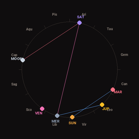
Moon: First Quarter (63% illuminated), in Capricorn.
Notable planetary angles: Moon square Saturn (91°), Sun sextile Mars (62°), Mercury sextile Jupiter (58°), Mercury opposite Saturn (177°).
Concurrent space weather: planetary Kp index 2.3; strongest recent solar flare: nothing notable.
This is a factual snapshot, not a claim of cause and effect – researchers are divided on whether lunar, planetary or solar factors influence seismic or weather activity. It’s included so readers can track the pattern for themselves over time.