The National Weather Service office in Tallahassee, Florida issued a Flash Flood Warning at 4:34 PM EDT on October 9, in effect until 10:30 PM EDT the same evening. The warning covers three counties in the Florida Panhandle: Franklin, Liberty, and Wakulla.
A Flash Flood Warning means flooding is already happening or is about to happen very soon – this is a step above a watch, which only means conditions are favorable. In practice, that means heavy rain is falling faster than the ground, creeks, and drainage systems in these counties can handle it.
Residents in the warned areas may notice rapidly rising water on roads, in ditches, and in low-lying spots, especially along small streams and in poor-drainage neighborhoods. Roads can go from wet to impassable in minutes, and water levels on small creeks can rise several feet in under an hour.
What to do during this warning
If you are in Franklin, Liberty, or Wakulla County this evening, avoid driving unless necessary, and never drive through water covering a road – just six inches of moving water can knock a person down, and about a foot can carry away most vehicles. The phrase ‘turn around, don’t drown’ exists because most flash flood deaths happen in vehicles.
If you live near a creek, in a low-lying area, or in a spot that has flooded before, be ready to move to higher ground quickly. Keep a phone charged, a flashlight handy, and pay attention to any additional alerts from local emergency management, since warnings can be extended or expanded if rain keeps falling.
The warning currently expires at 10:30 PM EDT, but conditions will be reassessed as the evening progresses. After the rain ends, treat standing water on roads with caution even in daylight – floodwater can hide washed-out pavement and debris.
This information comes from the National Weather Service office in Tallahassee, Florida.
Frequently Asked Questions
Which areas are under this Flash Flood Warning?
Three Florida Panhandle counties are covered: Franklin, Liberty, and Wakulla. The warning was issued by NWS Tallahassee at 4:34 PM EDT on October 9.
How long will the warning last?
It is currently set to expire at 10:30 PM EDT on October 9. The National Weather Service can extend, expand, or cancel it depending on how the rain develops.
What should I do right now if I'm in the warned area?
Stay off the roads if you can, and never drive through water covering the pavement – turn around and find another route. If you're in a flood-prone or low-lying spot, be ready to move to higher ground quickly.
Is it safe to go out once the heavy rain stops?
Be cautious even after the rain ends, since floodwater can linger and can hide washed-out roads or debris. Wait for official word that roads are clear before traveling through previously flooded areas.
Keep tracking this:
Source: National Weather Service (NWS)
Related Reading
- Emergency Communication: Staying Connected When Towers Go Down
- Earthquake Survival: Precautions, Kit & Early Warning in 2026
- Essential Guide to Preparing for a Nuclear War
Sky & Solar Conditions at the Time
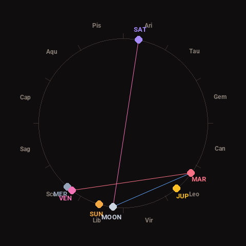
Moon: New Moon (1% illuminated), in Libra.
Notable planetary angles: Moon sextile Mars (60°), Venus square Mars (91°), Moon opposite Saturn (176°), Mercury conjunct Venus (4°).
Concurrent space weather: planetary Kp index 1.0; strongest recent solar flare: nothing notable.
This is a factual snapshot, not a claim of cause and effect – researchers are divided on whether lunar, planetary or solar factors influence seismic or weather activity. It’s included so readers can track the pattern for themselves over time.