The National Weather Service office in Jackson, Kentucky issued a Flash Flood Warning late Tuesday night, September 23, at 11:10 PM EDT. The warning remains in effect until 1:00 AM EDT on Wednesday, September 24, and covers four areas: Harlan County, Kentucky; Bell County, Kentucky; Leslie County, Kentucky; and Knox County, Tennessee.
A Flash Flood Warning means flooding is already occurring or is about to happen very soon – this is not just a possibility, it is the highest level of short-term flood alert. Heavy rain falling over a short period can overwhelm small streams, creeks, and drainage systems in minutes, especially in the steep, mountainous terrain of this region where water funnels quickly into hollows and valleys.
People in the affected counties may notice rapidly rising water on roads, swollen creeks, water pooling in low-lying areas, and in some spots mud or debris washing across roadways. Overnight warnings are especially dangerous because floodwater is hard to see in the dark, and many flash flood deaths happen in vehicles.
What to watch for
Do not drive through flooded roads. Just six inches of moving water can knock a person down, and a foot or two can carry away a vehicle. Turn around and find another route.
Move to higher ground if you live near a creek or in a low-lying area. If water is rising toward your home, get up and out – don’t wait for an official evacuation order.
Keep a phone charged and alerts on overnight. The warning currently runs until 1:00 AM EDT, but it could be extended if heavy rain continues.
This alert is based on data from the National Weather Service office in Jackson, Kentucky.
Frequently Asked Questions
Is this warning still active?
The warning is in effect from 11:10 PM EDT on September 23 until 1:00 AM EDT on September 24. If heavy rain continues, the NWS may extend it or issue follow-up warnings, so keep local alerts on overnight.
What's the difference between a watch and this warning?
A watch means conditions are favorable for flash flooding, while a warning means flooding is happening now or is imminent. A warning calls for immediate action, not just monitoring.
What should I do right now if I'm in one of these counties?
Stay off the roads if possible, avoid creeks and low-lying areas, and move to higher ground if water is rising near your home. Never attempt to drive or walk through floodwater, especially at night.
Why is this area prone to flash flooding?
The steep terrain of southeast Kentucky funnels heavy rain quickly into narrow valleys, creeks, and hollows, causing water to rise fast with little warning. Even a couple of inches of rain in a short time can trigger dangerous flooding there.
Keep tracking this:
Source: National Weather Service (NWS)
Related Reading
- Emergency Communication: Staying Connected When Towers Go Down
- Earthquake Survival: Precautions, Kit & Early Warning in 2026
- Essential Guide to Preparing for a Nuclear War
Sky & Solar Conditions at the Time
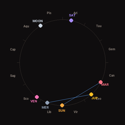
Moon: Waxing Gibbous (93% illuminated), in Aquarius.
Notable planetary angles: Mercury sextile Jupiter (63°), Sun sextile Mars (63°).
Concurrent space weather: planetary Kp index 3.0; strongest recent solar flare: nothing notable.
This is a factual snapshot, not a claim of cause and effect – researchers are divided on whether lunar, planetary or solar factors influence seismic or weather activity. It’s included so readers can track the pattern for themselves over time.