The National Weather Service office in Tucson, Arizona issued a Flash Flood Warning on September 13 at 8:12 PM MST, remaining in effect until 9:45 PM MST the same evening. The warning currently covers three areas: Cochise County, Arizona; Coconino County, Arizona; and Rio Blanco County, Colorado.
A flash flood warning means flooding is already occurring or is imminent — this is a step beyond a watch, which only means conditions are favorable. These warnings are typically triggered by heavy rainfall from slow-moving thunderstorms, radar estimates of intense rain, or reports from trained spotters and emergency officials.
What You Might Notice
Residents in the warned areas may see rapidly rising water in normally dry washes, creeks, and arroyos — a particular hazard in the desert Southwest, where hard, dry soil cannot absorb heavy rain quickly. Water can also pond on roads, underpasses, and low-lying areas within minutes of intense rainfall. You may hear weather radio alerts or receive wireless emergency alerts on your phone.
Who is affected: anyone in or traveling through Cochise and Coconino counties in Arizona, or Rio Blanco County in Colorado, during the warning window. This includes drivers on rural highways, campers and hikers in canyon or wash terrain, and residents in low-lying or poor-drainage areas.
Practical steps to take right now:
1. Never drive through flooded roads. Just six inches of moving water can knock a person down, and a foot of water can carry away most vehicles. Turn around, don’t drown.
2. Move to higher ground if you’re near a wash, creek, or slot canyon. Flash floods can arrive downstream even where it isn’t raining.
3. Keep alerts enabled on your phone and monitor local conditions until the warning expires at 9:45 PM MST, as warnings can be extended if heavy rain continues.
This information comes from the National Weather Service (NWS) Tucson office, part of NOAA.
Frequently Asked Questions
What should I do right now if I'm in one of these areas?
Move away from washes, creeks, and low-lying roads, and get to higher ground if water is rising. Do not attempt to drive or walk through floodwater — most flash flood deaths happen in vehicles.
How long will this warning last?
The warning is in effect until 9:45 PM MST on September 13, about 90 minutes after it was issued. The NWS may extend, expand, or cancel it early depending on how the storms behave.
It isn't raining where I am — am I still at risk?
Possibly, yes. Flash floods in the Southwest often strike downstream from where the rain actually fell, so a dry wash near you can fill suddenly with runoff from a storm miles away.
What's the difference between a watch and a warning?
A watch means conditions are favorable for flash flooding, while a warning means flooding is happening or about to happen. A warning calls for immediate action, not just preparation.
Keep tracking this:
Source: National Weather Service (NWS)
Related Reading
- Emergency Communication: Staying Connected When Towers Go Down
- Earthquake Survival: Precautions, Kit & Early Warning in 2026
- Essential Guide to Preparing for a Nuclear War
Sky & Solar Conditions at the Time
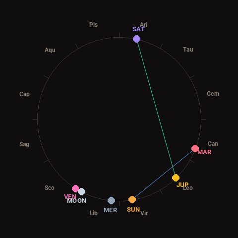
Moon: Waxing Crescent (10% illuminated), in Libra.
Notable planetary angles: Sun sextile Mars (60°), Jupiter trine Saturn (123°).
Concurrent space weather: planetary Kp index 1.0; strongest recent solar flare: nothing notable.
This is a factual snapshot, not a claim of cause and effect – researchers are divided on whether lunar, planetary or solar factors influence seismic or weather activity. It’s included so readers can track the pattern for themselves over time.