The National Weather Service in Tallahassee issued a Tropical Storm Warning at 2:10 AM EDT on October 10, covering nine marine zones along the Florida Panhandle and Big Bend coastline. A Tropical Storm Warning means tropical storm conditions – sustained winds of 39 to 73 mph – are expected in the warned area within 36 hours.
The warning covers St. Andrews Bay waterways and a long stretch of Gulf waters, from the Okaloosa-Walton County line near Destin eastward past Panama City, Mexico Beach, Apalachicola, and the Ochlockonee River, down through Apalachee Bay to Keaton Beach and the Suwannee River. It applies both to nearshore waters out to 20 nautical miles and offshore zones from 20 to 60 nautical miles out.
Anyone on or near the water in this region should expect building seas, strengthening winds, and deteriorating conditions through the day. Small craft, fishing boats, and recreational boaters are the most directly affected, but coastal communities along the warned shoreline can also expect gusty winds, rough surf, rip currents, and possible minor coastal flooding at high tide.
What to do now
If you have a boat in the warned area, secure it or get to safe harbor as soon as possible – conditions can go from manageable to dangerous quickly. Beachgoers should stay out of the water; rip current risk will be high even before the worst weather arrives. Coastal residents should secure loose outdoor items, charge phones, and monitor local NWS updates in case the warning is upgraded or expanded inland.
This information comes from the National Weather Service office in Tallahassee, Florida, part of NOAA’s National Weather Service.
Frequently Asked Questions
Which areas are under this Tropical Storm Warning?
Nine marine zones along the Florida Panhandle and Big Bend, from the Okaloosa-Walton County line east past Panama City, Mexico Beach, and Apalachicola, down through Apalachee Bay to Keaton Beach and the Suwannee River – including both nearshore waters (out to 20 nautical miles) and offshore waters (20 to 60 nautical miles out).
What should I do right now if I'm on the water?
Head to safe harbor immediately and secure your vessel – tropical storm conditions (winds of 39-73 mph) are expected within 36 hours. Do not attempt to ride out the storm on the water, even in a larger boat.
Is it safe to swim at Panhandle beaches?
No – rough surf and dangerous rip currents are expected along the warned coastline, even well before the strongest winds arrive. Stay out of the Gulf until the warning is lifted and local officials say conditions have improved.
How long will this warning last?
The warning remains in effect until the storm passes and conditions improve, which the NWS will determine based on the storm's track and speed. Check for updated statements from NWS Tallahassee, which can upgrade, downgrade, or cancel the warning as the situation evolves.
Keep tracking this:
Source: National Weather Service (NWS)
Related Reading
- Emergency Communication: Staying Connected When Towers Go Down
- Earthquake Survival: Precautions, Kit & Early Warning in 2026
- Essential Guide to Preparing for a Nuclear War
Sky & Solar Conditions at the Time
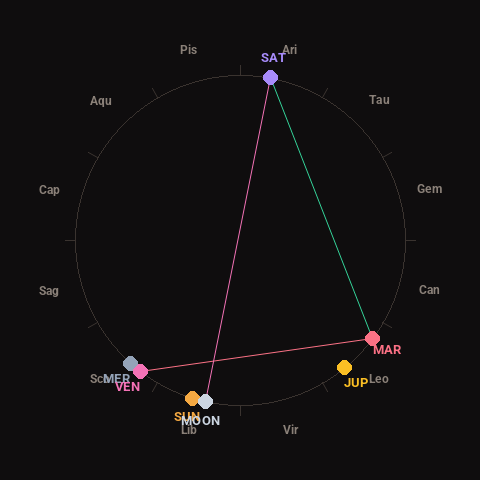
Moon: New Moon (0% illuminated), in Libra.
Notable planetary angles: Venus square Mars (91°), Moon opposite Saturn (178°), Mars trine Saturn (116°).
Concurrent space weather: planetary Kp index 3.0; strongest recent solar flare: nothing notable.
This is a factual snapshot, not a claim of cause and effect – researchers are divided on whether lunar, planetary or solar factors influence seismic or weather activity. It’s included so readers can track the pattern for themselves over time.