The National Weather Service office in Honolulu has issued a Tropical Storm Warning for two marine areas around the island of Kauai: the Kauai Channel and Kauai’s Windward Waters. The warning was issued at 11:09 PM HST on September 6.
A Tropical Storm Warning means that tropical storm conditions – sustained winds of 39 to 73 mph, along with rough seas – are expected in the warned area within 36 hours. This alert is aimed primarily at mariners, since the zones covered are coastal waters rather than land areas.
What readers might notice: Boaters and fishermen in the Kauai Channel and along Kauai’s windward (east-facing) coast can expect rapidly deteriorating conditions, including building seas, strong gusts, heavy rain squalls, and poor visibility. On shore, residents on Kauai may notice increasing surf on windward-facing beaches, stronger breezes, and passing showers as the storm influences the region.
Who is affected: Anyone operating vessels in the Kauai Channel or Kauai’s windward waters is directly affected and should already be in port or heading there. Beachgoers, swimmers, and surfers along Kauai’s east side should also take this seriously, as surf and rip currents typically worsen well before the worst weather arrives.
Sensible steps right now
1. Secure or avoid small craft. If you have a boat in the warned waters, get it secured in harbor. Do not attempt to transit the Kauai Channel until the warning is lifted and seas subside.
2. Stay out of the water on windward shores. Rough surf and dangerous rip currents often arrive ahead of the strongest winds. Keep clear of rocky shorelines and exposed east-facing beaches.
3. Monitor local updates. Conditions in the Hawaiian Islands can change quickly as tropical systems approach. Follow NWS Honolulu for updated advisories, including whether land-based warnings (such as wind or flood watches) are added for Kauai.
Data for this alert comes from the National Weather Service Honolulu office.
Frequently Asked Questions
Does this warning cover the island of Kauai itself?
This warning covers marine zones – the Kauai Channel and Kauai Windward Waters – not land areas. However, rough surf and gusty conditions on Kauai's windward side are still likely, and residents should watch for any additional land-based advisories from NWS Honolulu.
What should I do right now if I'm in the affected area?
Mariners should get vessels secured in port immediately and avoid the warned waters. On land, stay off windward beaches and out of the ocean until conditions improve.
How long will this last?
A Tropical Storm Warning indicates storm conditions are expected within 36 hours. The exact duration depends on the storm's track and speed – follow NWS Honolulu updates for the latest timing.
Is it dangerous to swim or surf on Kauai right now?
Yes, particularly on windward (east-facing) shores. Tropical storms generate rough surf and strong rip currents well before the worst winds arrive, so staying out of the water is the safest choice until the warning is lifted.
Keep tracking this:
Source: National Weather Service (NWS)
Related Reading
- Emergency Communication: Staying Connected When Towers Go Down
- Earthquake Survival: Precautions, Kit & Early Warning in 2026
- Essential Guide to Preparing for a Nuclear War
Sky & Solar Conditions at the Time
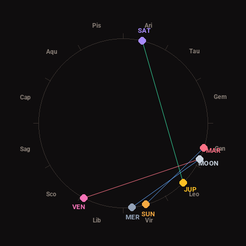
Moon: Waning Crescent (17% illuminated), in Cancer.
Notable planetary angles: Moon sextile Mercury (59°), Jupiter trine Saturn (122°), Moon square Venus (92°), Sun sextile Mars (57°).
Concurrent space weather: planetary Kp index 3.3; strongest recent solar flare: nothing notable.
This is a factual snapshot, not a claim of cause and effect – researchers are divided on whether lunar, planetary or solar factors influence seismic or weather activity. It’s included so readers can track the pattern for themselves over time.