The National Weather Service office in Northern Indiana has issued a Flood Warning covering 32 counties across six states, in effect from 1:11 AM EDT on September 24 until 8:00 PM EDT on September 25. The warning area includes Allen, Adams, and Wells counties in Indiana; Van Wert County in Ohio; Lake, Kenosha, and Hancock counties across Illinois and Wisconsin; and counties stretching west into Iowa and Missouri, including Des Moines, Lee, and Clark. In total, 32 areas are under the warning.
A Flood Warning means flooding is already occurring or is imminent — this is a step above a Flood Watch, which only signals that conditions are favorable. The wide geographic spread suggests a slow-moving storm system or a period of heavy, repeated rainfall across the Midwest, with rivers, creeks, and low-lying areas at risk of rising above their banks.
What you might notice
Residents in the affected counties may see water ponding on roads, ditches and storm drains overflowing, and small streams rising quickly. Rivers such as the Maumee, Wabash, and their tributaries in northeast Indiana and northwest Ohio are typical trouble spots during events like this. Urban areas, including the Fort Wayne and greater Chicago metro fringes, can see street flooding even where rivers stay within banks. Commuters should expect slower travel, occasional road closures, and possible water over rural roads, especially overnight and in low spots.
If you live, work, or travel in any of the 32 warned counties, a few sensible steps apply:
1. Never drive through flooded roads. It takes only about a foot of moving water to carry away a small car. Turn around and find another route — most flood deaths happen in vehicles.
2. Move valuables off basement floors if your home is prone to seepage, and check that sump pumps are working before the heaviest rain arrives.
3. Keep phones charged and alerts enabled. Warnings can be upgraded or extended if rainfall outperforms forecasts, and flash flood warnings can be issued on short notice for specific creeks or neighborhoods.
The warning currently runs through 8:00 PM EDT on September 25, but it may be extended, expanded, or replaced with more localized warnings as conditions evolve. This information comes from the National Weather Service (NWS Northern Indiana) and NOAA.
Frequently Asked Questions
What should I do right now if I'm in one of the warned counties?
Avoid driving through any water-covered road, keep your phone charged with wireless emergency alerts enabled, and move belongings off basement floors if your home has flooded before.
How long will this flooding last?
The warning is currently set to expire at 8:00 PM EDT on September 25, but the NWS can extend or expand it if rainfall continues or rivers keep rising.
Is my area included in this warning?
The warning covers 32 counties including Allen, Adams, Wells (IN), Van Wert (OH), Lake (IL), Kenosha (WI), Des Moines and Lee (IA), and Clark (MO), plus 22 additional areas — check the NWS for your specific county.
What's the difference between a Flood Watch and a Flood Warning?
A watch means flooding is possible; a warning means it is happening or about to happen. This is a warning, so take it as an active event, not a maybe.
Keep tracking this:
Source: National Weather Service (NWS)
Related Reading
- Emergency Communication: Staying Connected When Towers Go Down
- Earthquake Survival: Precautions, Kit & Early Warning in 2026
- Essential Guide to Preparing for a Nuclear War
Sky & Solar Conditions at the Time
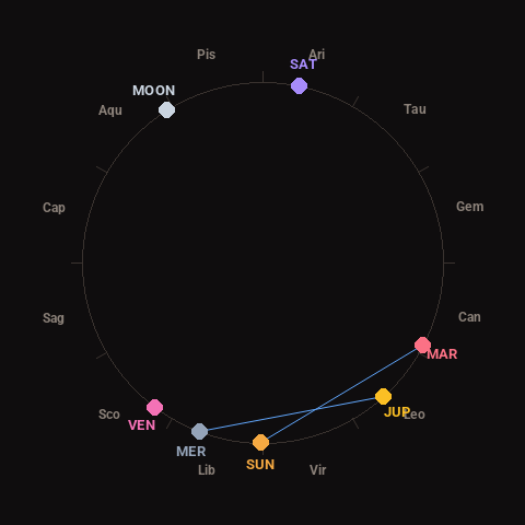
Moon: Waxing Gibbous (92% illuminated), in Aquarius.
Notable planetary angles: Mercury sextile Jupiter (63°), Sun sextile Mars (63°).
Concurrent space weather: planetary Kp index 2.3; strongest recent solar flare: nothing notable.
This is a factual snapshot, not a claim of cause and effect – researchers are divided on whether lunar, planetary or solar factors influence seismic or weather activity. It’s included so readers can track the pattern for themselves over time.