The National Weather Service office in Mobile, Alabama, has issued a Flood Warning covering 34 areas across the Gulf Coast and surrounding regions. The warning was issued in the early morning hours of October 10 at 12:46 AM CDT and remains in effect until 1:00 PM CDT on October 13 – a stretch of more than three days.
Affected counties include Okaloosa, Walton, and Santa Rosa in the Florida Panhandle; Clay and Duval in northeast Florida (which includes the Jacksonville area); Conecuh, Covington, Crenshaw, and Escambia counties in southern Alabama; and Hardin County in southeast Texas, plus two dozen additional areas. This is an unusually broad footprint, suggesting widespread heavy rainfall and rising rivers, creeks, and streams across multiple states.
What You Might Notice
A Flood Warning means flooding is already occurring or is imminent – it is more serious than a Flood Watch, which only means conditions are favorable. Residents in the affected counties may see water covering roads, especially low-lying and rural routes, standing water in yards and fields, and elevated water levels in rivers and drainage canals. If the warning includes your county, some roads you normally use could be closed or impassable over the next few days.
Because the warning runs through October 13, this points to a slow-moving weather system or rivers that take time to crest and recede after heavy rain. Conditions may vary county by county, so check local updates even if skies look clear overhead – flooding downstream can arrive well after the rain stops.
Practical steps right now: Never drive through water covering a road – just six inches of moving water can knock a person down, and a foot can carry away a small car. Turn around and find another route. Move vehicles and valuables out of low-lying areas, and avoid walking near swollen creeks or ditches. Keep a phone charged and monitor local alerts in case warnings are upgraded or extended.
Data for this alert comes from the National Weather Service (NWS) Mobile, Alabama office.
Frequently Asked Questions
Is my area under this warning?
The warning covers 34 areas, including Okaloosa, Walton, Santa Rosa, Clay, and Duval counties in Florida; Conecuh, Covington, Crenshaw, and Escambia counties in Alabama; and Hardin County in Texas. Check your local National Weather Service office to confirm whether your specific county is included.
What's the difference between a Flood Warning and a Flood Watch?
A Flood Warning, like this one, means flooding is happening now or about to happen. A Flood Watch only means conditions are favorable for flooding. A warning calls for immediate caution.
How long will the flooding last?
This warning is in effect until 1:00 PM CDT on October 13 – more than three days. River flooding can linger even after rain ends, so conditions may improve at different times in different counties.
What should I do right now?
Avoid driving or walking through flooded roads – most flood deaths happen in vehicles. Move valuables and vehicles out of low-lying areas, keep your phone charged, and follow any instructions from local officials.
Keep tracking this:
Source: National Weather Service (NWS)
Related Reading
- Emergency Communication: Staying Connected When Towers Go Down
- Earthquake Survival: Precautions, Kit & Early Warning in 2026
- Essential Guide to Preparing for a Nuclear War
Sky & Solar Conditions at the Time
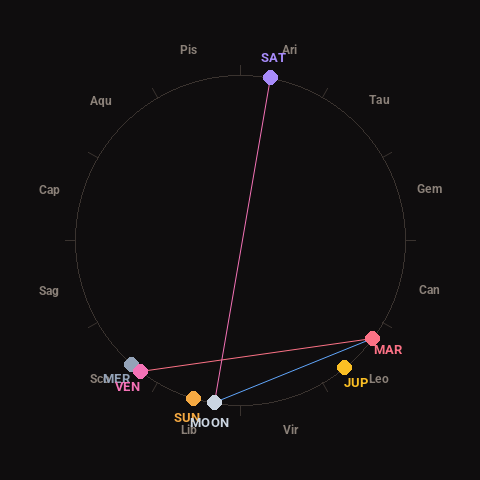
Moon: New Moon (0% illuminated), in Libra.
Notable planetary angles: Venus square Mars (91°), Moon opposite Saturn (178°), Moon sextile Mars (63°).
Concurrent space weather: planetary Kp index 2.3; strongest recent solar flare: nothing notable.
This is a factual snapshot, not a claim of cause and effect – researchers are divided on whether lunar, planetary or solar factors influence seismic or weather activity. It’s included so readers can track the pattern for themselves over time.