The National Weather Service office in Norman, Oklahoma has issued a Flood Warning covering 26 counties in central and western Oklahoma and southern Kansas. The warning was issued at 2:27 PM CDT on October 14 and remains in effect until 9:00 PM CDT on October 15 — a window of roughly 30 hours.
Counties included in the warning cover Canadian, Oklahoma, Cleveland, Blaine, Caddo, Custer, Dewey, Kingfisher, and Logan counties in Oklahoma, plus Sumner County in Kansas, along with 16 additional areas. Oklahoma City and much of the surrounding metro fall within the warned area.
What you might notice
A Flood Warning means flooding is already occurring or is imminent — this is a step above a Flood Watch, which only signals that conditions are favorable. Residents in the warned counties may see water over roads, swollen creeks and small rivers, and ponding in low-lying areas, underpasses, and poor-drainage spots. Rural roads and low-water crossings, common across central Oklahoma and southern Kansas, are especially prone to washing out or becoming impassable during heavy rain.
What to do
First, never drive through water covering a road — just 6 to 12 inches of moving water can stall or sweep away most vehicles. Turn around and find another route, especially at night when depth is hard to judge. Second, if you live near a creek or in a flood-prone area, move valuables and electronics to higher ground and be ready to relocate to higher floors if water rises. Third, keep a phone charged and a weather radio or local news alerts active overnight, since conditions can change quickly after dark when flooding is hardest to see.
This information comes from the National Weather Service (NOAA), Norman, Oklahoma forecast office.
Frequently Asked Questions
Is Oklahoma City affected by this flood warning?
Yes. Oklahoma County, which includes most of Oklahoma City, is explicitly listed, along with neighboring Cleveland, Canadian, and Logan counties that make up much of the metro area.
How long will the flooding risk last?
The warning runs until 9:00 PM CDT on October 15, so hazardous conditions could persist for roughly 30 hours from the time it was issued. The NWS may extend, expand, or cancel the warning as conditions change.
What should I do if I come across a flooded road?
Turn around and find another route — never drive or walk through floodwater. Even shallow moving water can sweep away a vehicle, and the road underneath may be washed out.
Does this warning affect Kansas too?
Yes. Sumner County in southern Kansas, along the Oklahoma border and south of Wichita, is among the 26 areas included in the warning.
Keep tracking this:
Source: National Weather Service (NWS)
Related Reading
- Emergency Communication: Staying Connected When Towers Go Down
- Earthquake Survival: Precautions, Kit & Early Warning in 2026
- Essential Guide to Preparing for a Nuclear War
Sky & Solar Conditions at the Time
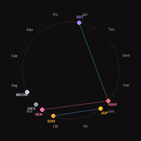
Moon: Waxing Crescent (13% illuminated), in Sagittarius.
Notable planetary angles: Sun sextile Jupiter (59°), Mars trine Saturn (119°), Venus square Mars (87°).
Concurrent space weather: planetary Kp index 2.0; strongest recent solar flare: nothing notable.
This is a factual snapshot, not a claim of cause and effect – researchers are divided on whether lunar, planetary or solar factors influence seismic or weather activity. It’s included so readers can track the pattern for themselves over time.