The National Weather Service office in New Orleans has issued a Hurricane Warning covering 24 areas along the northern Gulf Coast, including coastal Alabama, the western Florida Panhandle, and coastal Mississippi waters. The warning was issued at 9:59 PM CDT on October 7.
A Hurricane Warning means hurricane conditions — sustained winds of 74 mph or higher — are expected somewhere within the warned area, typically within 36 hours. This is a step above a Hurricane Watch and signals that preparations should be completed quickly, not just planned.
Areas covered include Southern Jackson County, North and South Mobile Bay, the Mississippi Sound, Perdido Bay, the Pensacola Bay area including Santa Rosa Sound, and the coastal and offshore waters from the Okaloosa-Walton County line in Florida west to Pascagoula, Mississippi, extending out to 60 nautical miles. That puts communities in and around Mobile, Gulf Shores, Pensacola, and the Mississippi barrier islands squarely in the impact zone.
What you might notice
Before the strongest winds arrive, expect rough surf and dangerous rip currents along the beaches, rapidly rising water in bays and sounds, squally rain bands, and increasing wind gusts. Mariners should already be off the water — conditions in the Mississippi Sound and Gulf waters will become life-threatening. Power outages become likely once sustained tropical-storm-force winds arrive, and low-lying coastal roads may flood ahead of the main storm due to surge and wave action.
Sensible steps right now:
1. If local officials have issued evacuation orders for your zone, leave now — don’t wait for conditions to deteriorate. Know your evacuation route and bring medications, documents, and a charged phone.
2. Secure or bring inside anything outdoors that can become airborne: patio furniture, grills, trash cans, and decorations.
3. Charge devices, fill your vehicle’s tank, and have flashlights, water, and non-perishable food ready for at least 72 hours in case of extended outages.
Monitor official forecasts closely, as the exact landfall point and storm surge values will determine which neighborhoods face the worst impacts. Small shifts in track can make a big difference in local conditions.
Data and official warning details for this alert come from the National Weather Service (NWS) New Orleans office and NOAA.
Frequently Asked Questions
What should I do right now if I'm in the warned area?
Finish storm preparations tonight — secure outdoor items, charge devices, and gather supplies. If you live in a storm surge evacuation zone and officials have ordered evacuations, leave as soon as possible rather than waiting.
How long will hurricane conditions last?
Hurricane Warnings are typically issued about 36 hours before the expected onset of tropical-storm-force winds. The worst conditions usually last 6 to 12 hours at any given location, though rain, flooding, and power outages can persist for days afterward.
Is Mobile Bay and Pensacola Bay at risk of storm surge?
Yes — both bays are explicitly included in the warning, and shallow bays and sounds like these are especially prone to surge-driven flooding. Low-lying waterfront areas should be prepared for significant water rise.
I'm on a boat in the Mississippi Sound or Gulf waters — what should I do?
Get to port immediately. The warned waters out to 60 nautical miles will see seas and winds no recreational vessel can safely handle, and Coast Guard rescues generally aren't possible once conditions deteriorate.
Keep tracking this:
Source: National Weather Service (NWS)
Related Reading
- Emergency Communication: Staying Connected When Towers Go Down
- Earthquake Survival: Precautions, Kit & Early Warning in 2026
- Essential Guide to Preparing for a Nuclear War
Sky & Solar Conditions at the Time
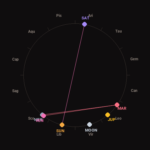
Moon: Waning Crescent (7% illuminated), in Virgo.
Notable planetary angles: Mercury conjunct Venus (1°), Venus square Mars (92°), Mercury square Mars (94°), Sun opposite Saturn (176°).
Concurrent space weather: planetary Kp index 1.0; strongest recent solar flare: nothing notable.
This is a factual snapshot, not a claim of cause and effect – researchers are divided on whether lunar, planetary or solar factors influence seismic or weather activity. It’s included so readers can track the pattern for themselves over time.