The National Weather Service office in New Orleans issued a Tropical Storm Warning late Tuesday night, October 7, at 9:59 PM CDT. The warning covers nine areas along the northern Gulf Coast, including parts of southeast Louisiana and coastal Mississippi.
The affected areas are: Southeast St. Tammany, Eastern Orleans, Lower St. Bernard, and Lower Plaquemines parishes in Louisiana, plus Southern Hancock, Northern Hancock, Southern Harrison, Northern Harrison, and Northern Jackson counties in Mississippi. This includes communities around New Orleans, Bay St. Louis, Gulfport, and Biloxi.
What a Tropical Storm Warning Means
A Tropical Storm Warning means tropical storm conditions — sustained winds of 39 to 73 mph — are expected within the warning area, generally within 36 hours. Residents can expect gusty winds, periods of heavy rain, and the possibility of downed tree limbs and scattered power outages. Low-lying and coastal areas may also see minor flooding from elevated tides and rainfall.
For most people in well-built homes, this level of storm is manageable with basic preparation. The main concerns are falling branches, brief outages, localized street flooding, and hazardous driving conditions, especially on bridges and causeways where winds are stronger.
What You Can Do Now
First, secure or bring indoors anything outside that could blow around — patio furniture, trash cans, plants, and decorations. Second, charge phones and portable batteries tonight in case of power interruptions, and make sure flashlights are handy. Third, avoid driving through flooded roads during the storm; even shallow moving water can stall or carry a vehicle. Keep an eye on updated forecasts, since the warning area or timing can shift as the system moves.
This information comes from the National Weather Service (NWS) office in New Orleans, part of NOAA.
Frequently Asked Questions
What should I do right now?
Bring in or tie down loose outdoor items, charge your devices, and make sure you have flashlights and any needed medications ready. Avoid non-essential travel once winds pick up, especially on bridges and causeways.
How strong will the winds get?
Tropical storm conditions mean sustained winds of 39 to 73 mph with higher gusts. That's enough to bring down small tree limbs and cause scattered power outages, but well-built homes typically handle it fine.
Will my area flood?
Low-lying coastal spots, especially in Lower Plaquemines, Lower St. Bernard, and the Mississippi coast, could see minor flooding from elevated tides and heavy rain. Never drive through water covering a road.
How long will this warning last?
Tropical storm warnings typically remain in effect until the system passes, usually within 12 to 36 hours of issuance. Monitor NWS New Orleans updates, as the warning can be extended, expanded, or cancelled as the storm evolves.
Keep tracking this:
Source: National Weather Service (NWS)
Related Reading
- Emergency Communication: Staying Connected When Towers Go Down
- Earthquake Survival: Precautions, Kit & Early Warning in 2026
- Essential Guide to Preparing for a Nuclear War
Sky & Solar Conditions at the Time
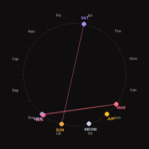
Moon: Waning Crescent (7% illuminated), in Virgo.
Notable planetary angles: Mercury conjunct Venus (1°), Venus square Mars (92°), Mercury square Mars (94°), Sun opposite Saturn (176°).
Concurrent space weather: planetary Kp index 1.0; strongest recent solar flare: nothing notable.
This is a factual snapshot, not a claim of cause and effect – researchers are divided on whether lunar, planetary or solar factors influence seismic or weather activity. It’s included so readers can track the pattern for themselves over time.