
Last updated November 17, 2026 at 15:45 UTC. This page is updated in place as the situation changes, rather than published as a new article each time.
The National Weather Service office in Fairbanks has issued a Blizzard Warning for St. Lawrence Island, Alaska, effective from 3:12 AM AKST on November 17 through 3:00 PM AKST on November 19. That is roughly two and a half days of expected blizzard conditions for the island, which sits in the Bering Sea between Alaska and Russia and is home to the communities of Gambell and Savoonga.
A blizzard warning means sustained winds or frequent gusts of 35 mph or greater are expected, combined with falling or blowing snow that drops visibility to a quarter mile or less for at least three hours. In practical terms, residents on the island should expect near-whiteout conditions at times, deep drifting snow, and dangerous wind chills. Travel on the island — mostly by snowmachine and on foot between or within villages — could become life-threatening if anyone is caught outside during the worst of it.
What residents and families should watch
For the roughly 1,400 people living on St. Lawrence Island, the main concerns are loss of visibility, drifting snow blocking roads and doors, and possible interruptions to power or communications. Air travel to and from the island is very likely to be delayed or canceled while the warning is in effect, so anyone expecting flights, mail, or freight should plan on disruptions through midweek. Subsistence activities such as hunting or checking gear offshore should be postponed until conditions improve.
Sensible steps right now: stay indoors and off the trail system once conditions deteriorate; make sure each household has food, water, fuel, batteries, and charged devices for at least a couple of days; and check on elders and neighbors, especially anyone who may need help heating their home. Keep a battery-powered or hand-crank radio or phone handy for updates from local sources, and keep exterior vents and doorways clear of drifting snow to prevent carbon monoxide buildup from heating systems.
Conditions are expected to gradually improve after the warning expires at 3:00 PM AKST on November 19, though lingering blowing snow is common after a system like this moves through the Bering Sea. Residents should continue to monitor local advisories in case the warning is extended or upgraded.
This alert is based on official warning data issued by the National Weather Service (NWS) Fairbanks, Alaska office.
Frequently Asked Questions
How long will this blizzard last?
The warning runs from 3:12 AM AKST on November 17 until 3:00 PM AKST on November 19 — about 60 hours. Conditions should improve after that, though blowing snow can linger after the warning ends.
What should people on St. Lawrence Island do right now?
Stay indoors once conditions worsen, avoid snowmachine travel between or within villages, and make sure your household has food, fuel, water, and charged devices for a couple of days. Keep vents and doorways clear of drifting snow to prevent carbon monoxide buildup.
Will flights to Gambell or Savoonga be affected?
Very likely, yes — blizzard conditions with low visibility typically ground flights to the island's airstrips. Anyone expecting travel, mail, or freight should plan on delays through at least November 19.
Is this unusual for St. Lawrence Island?
Blizzards are a regular part of late fall and winter in the Bering Sea region, but a warning lasting more than two days is a significant event. Residents should treat it seriously and follow local and NWS updates.
Update History
Earlier updates on this page, newest first:
- Nov 16, 2026 – Blizzard Warning: St Lawrence Island (National Weather Service (NWS))
- Nov 15, 2026 – Blizzard Warning – 2 Areas Affected (National Weather Service (NWS))
- Nov 15, 2026 – Blizzard Warning – 3 Areas Affected (National Weather Service (NWS))
- Nov 14, 2026 – Blizzard Warning – 3 Areas Affected (National Weather Service (NWS))
- Nov 13, 2026 – Blizzard Warning – 3 Areas Affected (National Weather Service (NWS))
- Nov 12, 2026 – Blizzard Warning – 3 Areas Affected (National Weather Service (NWS))
- Nov 11, 2026 – Blizzard Warning – 3 Areas Affected (National Weather Service (NWS))
- Nov 11, 2026 – Blizzard Warning – 2 Areas Affected (National Weather Service (NWS))
- Nov 10, 2026 – Blizzard Warning – 3 Areas Affected (National Weather Service (NWS))
- Nov 9, 2026 – Blizzard Warning: Thompson Pass (National Weather Service (NWS))
- Oct 24, 2026 – Blizzard Warning in Effect for Northwest Alaska Coastal Areas Until Friday Morning
- Oct 23, 2026 – Blizzard Warning Issued for Alaska's Western Arctic and Seward Peninsula Coasts
- Oct 22, 2026 – Blizzard Warning Issued for Western Alaska Coast Through Early Friday
- Oct 21, 2026 – Blizzard Warning Issued for Western Alaska Coast and Seward Peninsula Through Early Friday
Keep tracking this:
Source: National Weather Service (NWS)
Related Reading
- Top 10 YouTube Videos on Boarding Up Windows for a Hurricane
- Emergency Communication: Staying Connected When Towers Go Down
- Earthquake Survival: Precautions, Kit & Early Warning in 2026
Sky & Solar Conditions at the Time
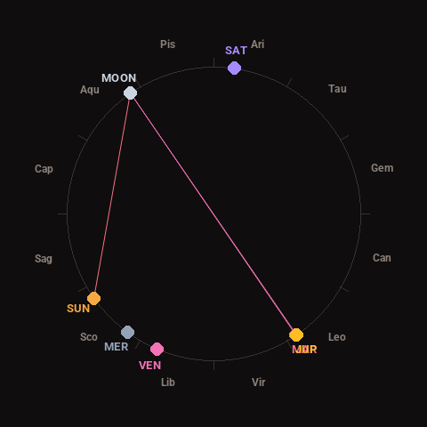
Moon: First Quarter (50% illuminated), in Aquarius.
Notable planetary angles: Moon opposite Jupiter (180°), Mars conjunct Jupiter (0°), Sun square Moon (91°), Moon opposite Mars (179°).
Concurrent space weather: planetary Kp index 0.7; strongest recent solar flare: nothing notable.
This is a factual snapshot, not a claim of cause and effect – researchers are divided on whether lunar, planetary or solar factors influence seismic or weather activity. It’s included so readers can track the pattern for themselves over time.